
Typhoon Haikui makes landfall for the third time! Why are autumn typhoons so powerful? How to deal with them scientifically?
|
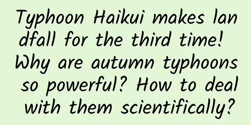
Monitoring by the Central Meteorological Observatory shows that the center of this year's No. 11 typhoon "Haikui" made landfall on the coast of Dongshan County, Fujian Province around 5:20 today (5th), and made landfall again on the coast of Raoping County, Guangdong Province around 6:45. The maximum wind speed near the center was 8 (18 meters/second) when it landed. This is the third time that Typhoon Haikui has landed in my country. Previously, Haikui made its first landfall on the coast of Taitung City, Taiwan Province on the 3rd. Typhoon rains continue in Fujian, Guangdong and other places Local precipitation may be extreme With the typhoon "Haikui" landing on the coast of southern China, coupled with the influence of the southwest monsoon water vapor transport , Fujian and Guangdong will become the "main battlefield" of heavy rainfall in the next two days , and the heavy rain warning is still in effect. In the next few days, Fujian and Guangdong and other places will continue to rain. Image source: China National Meteorological Administration The Guangdong Provincial Meteorological Observatory predicts that "Anemone" will move westward at a speed of 10 to 15 kilometers per hour and its intensity will gradually weaken. At present, according to the latest report from the Guangdong Provincial Flood Control, Drought Relief and Typhoon Prevention Headquarters, the railway department has suspended 515 trains, 23 sea passenger routes east of Huizhou have been suspended, and classes in Shantou and Chaozhou have been suspended. The Ministry of Water Resources and the China Meteorological Administration jointly issued a red meteorological warning for flash flood disasters at 18:00 on the 4th. It is expected that from 20:00 on the 4th to 20:00 on the 5th, there is a high possibility of flash flood disasters in parts of eastern and southern Fujian (orange warning), among which there is a high possibility of flash flood disasters in local areas of southern Fujian (red warning). Recent typhoon "groups" Why are autumn typhoons so crazy? Since the beginning of autumn, typhoons seem to have become "frequent visitors" and have frequently "visited". It feels to us that they are often "strong" or "super strong", making landfall from time to time, not only "clustering" but sometimes "forming groups", showing their arrogance. So, what exactly are autumn typhoons? Why are they so crazy? There is no strict meteorological definition for autumn typhoons. Typhoons that form from June to August are generally called summer typhoons, while those that form from September to November are called autumn typhoons . We know that the energy source for the growth of typhoons is mainly the heat in the ocean. During the transition period from summer to autumn, the sun moves from north to south, which causes the sea temperature to be warmer and more and more heat is accumulated on the sea surface. With sufficient energy supply, typhoons will grow stronger. After entering autumn, the subtropical high pressure begins to retreat eastward and move southward. As the main force affecting the typhoon path "declines", it gradually forms a "balanced" state with other system forces. In addition, the complex terrain of the South China Sea often causes typhoons to "take unusual paths" and have unpredictable paths. In addition, autumn typhoons are often easily combined with cold air moving south from the north to form a typhoon trough, which brings extremely strong winds and rains to the northern regions. The affected area is larger and the disaster losses are more serious. At 8:15 a.m. on September 1, as shown in the true color image of the Fengyun-4B geostationary meteorological satellite, "Sura", "Anemone" and "Hongyan" were distributed in an east-west belt. Image source: China Meteorological Administration How to deal with it scientifically? Find out with one picture! Image source: National Emergency Broadcasting Please pay attention to safety and take scientific precautions! Comprehensive sources: Xinhuanet, China Meteorological Administration, China Meteorological Administration, National Emergency Broadcasting, etc. |
>>: When is the best time to eat cookies and cakes to stabilize blood sugar?


Recommend
Three management tricks: Alibaba's magic tool for cultivating cadres
Three Management Axes - Introduction to Alibaba&#...
If smart drugs really exist, would you dare to take them?
Every exam season, rumors about "smart drugs...
The little red fruit "stained with snake saliva" is neither poisonous nor a fruit
As a botanist, the questions I answer most often ...
Android source code download: Bluetooth_4.3 BLE Bluetooth communication
Functional classification: Tools Supported platfo...
Nan'an SEO Training: How to achieve Baidu dominance through black hat SEO optimization?
Black hat SEO screen domination techniques have a...
Plant a tree, and your family won’t have to pay electricity bills for the rest of their lives… Is there such a good thing?!
Image source: sratup One day in 2011, French engi...
How to promote user sharing and dissemination?
For internet dogs, it is easy to organize an even...
The universal formula for e-commerce operations!
Recently I have been sorting out the e-commerce p...
What are the advantages and features of WeChat mini programs? How to obtain traffic?
Q: What are the advantages of mini programs in ac...
Meizu Blue challenges Redmi: Is there still a chance in the thousand-yuan phone market?
There have been rumors that Meizu will launch a t...
In-depth analysis of Pinduoduo’s product operations in 2019!
Jobs said that consumers don’t know what they nee...
How to operate a Douyin corporate account without experience and manpower?
With the rise of short video platforms, more and ...
Efficient App offline activity method!
As an App promotion operator , event promotion is...
Can eating chili peppers speed up the recovery of oral ulcers?
Recently, some netizens claimed that if you want ...
Inventory of SSDs with different interfaces: What platforms are they suitable for?
The poor reading and writing experience tells us ...