
Satellite "farming" is extraordinary! How does remote sensing technology help agricultural monitoring?
|
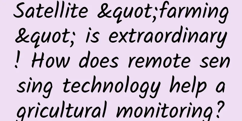
In the news broadcast, we often hear such reports: On a certain day of a certain month of a certain year, my country successfully launched a certain satellite... So what is a satellite? What is the use of a satellite? A satellite is a celestial body that orbits a planet and moves periodically in a closed orbit. The moon is the natural satellite of the earth. Unmanned spacecraft built and launched into space by humans and orbiting the earth like a natural satellite are also called satellites. So far, humans have launched more than 4,000 satellites into space. In addition to satellites used in scientific experiments and other fields, satellites used to perform business can be divided into communication satellites, navigation satellites and remote sensing satellites. Communication satellites are mainly used as radio communication relay stations to receive and forward radio signals; navigation satellites are mainly used for positioning and navigation, such as my country's Beidou; remote sensing satellites are mainly used to observe the earth system or objects. Based on the different objects of observation, they can be further divided into meteorological satellites, land satellites and ocean satellites. Here, we analyze how to use land satellites to identify crop categories from space. 1. Digital photos and satellite images Digital photos and satellite images Taking photos is one of the main functions of mobile phones nowadays. However, you may find it hard to imagine that it is also the main way to obtain data from land satellites. How to take photos of the earth more clearly and quickly has always been one of the main research directions of land satellites. Mobile phones carry cameras, and satellites also carry sensors. Satellites moving in fixed orbits continuously scan the ground through sensors and can periodically obtain photos of the earth, that is, satellite images. Satellite images generally cover a wide range, and the width of a satellite image can reach tens or even thousands of kilometers. The essence of light is electromagnetic waves. Photos obtained by mobile phones or digital cameras generally only contain energy in the three electromagnetic spectrum intervals of red, green and blue, while satellite sensors can further obtain the reflected energy of objects (ground objects) on the earth's surface in the near-infrared, short-wave infrared, microwave and other spectral intervals. Therefore, satellite images contain more available information. 2. Principle of crop identification Where are the fields? What is planted in the fields? How much is planted? This is a major issue related to food security and has attracted much attention from the society. How to use satellites to answer this question? The key lies in how to accurately identify various types of landforms and crops from satellite images. In essence, there is no obvious difference between mobile phone photos and satellite images. In photos, we generally distinguish different objects based on features such as color, shape, and roughness. In the photo shown in Figure 1, we can distinguish landforms such as rice fields, roads, and water bodies based on differences in color and roughness. In fact, the identification of various types of landforms or crops on satellite images is also mainly based on differences in features such as "color". In order to distinguish different landforms based on features such as "color", we must first understand why different landforms have different features such as "color", and secondly, what features different landforms have. In photos, the leaves of healthy vegetation such as forests, grasslands, and crops are generally green. This is mainly because the chlorophyll in the leaf cells has the characteristics of absorbing red light and blue-violet light and reflecting green light. Therefore, green occupies a dominant position in the photos in the red, green, and blue channels, making the leaves of vegetation appear green. Figure 1 Photo of rice fields In remote sensing images, due to the different interactions between different objects and electromagnetic waves, the reflected energy of the objects that can be received by the satellite is not consistent, which leads to the difference in "color" of different objects in different spectral intervals in remote sensing images, that is, the difference in reflectivity (Figure 2). This difference directly reflects the spectral characteristics of different objects. We can distinguish various types of objects from remote sensing images based on the difference in reflectivity or other feature differences derived from the reflectivity. Of course, in addition to the difference in reflectivity, different objects also have different features such as roughness (texture). Generally speaking, comprehensive multi-dimensional features can better identify different objects. Figure 2 Remote sensing image based on red, green and blue band synthesis (left) and reflectivity of main objects (right) 3. Crop identification method and planting area estimation In a large area, different objects may have the same or similar features. In theory, different objects have different reflectances, but in different regions, the reflectance differences of some objects are not obvious, especially for crops. Due to factors such as varieties, climate, and farming measures, the reflectance differences of different crops may be extremely weak. Therefore, high-precision crop identification is not a simple task. At present, the commonly used crop identification methods mainly include machine learning and phenological threshold methods. The machine learning method mainly obtains a certain amount of labeled samples containing real crop information in advance, and then uses the labeled samples to train the machine learning model so that the model "understands" what kind of features correspond to what kind of crops. The model is applied to remote sensing images to determine the category of each pixel on the remote sensing image, and finally achieves the purpose of crop identification. The basic idea of the phenological threshold method is that the characteristics of different crops change with the advancement of the growth process. These changes have certain regularities, and the change laws of different crops show certain differences. By distinguishing the change laws of different crops, the purpose of crop identification can be achieved. Figure 3 Crop identification (left) and planting area estimation (right) based on satellite remote sensing images Whether it is machine learning or phenological threshold method, the spatial distribution of different crops can be obtained based on satellite images (Figure 4). According to the spatial distribution map, we can calculate the number of pixels corresponding to different crops in the spatial distribution map, and then calculate the area of the corresponding crops, so as to achieve accurate measurement of crop planting area. Since satellite images cover a wide range, in theory, crop planting area can be calculated at a national or even global scale. Compared with the traditional method of statistically calculating crop planting area through household surveys and reporting at each level, crop planting area calculation based on satellite remote sensing technology not only saves time and effort, but also clarifies the spatial distribution of various crops, with greater objectivity and credibility. Satellite remote sensing technology has great potential in the field of agricultural monitoring. |
<<: Can an annual physical examination really help you “detect cancer early”?
>>: How to observe the death of a star?


Recommend
Server rental for thousands of people online at the same time
When renting a server with thousands of people on...
How did WeChat Mini Programs achieve over 100 million users?
Q: How did WeChat Mini Program achieve over 100 m...
Teacher Sun Qingjin's "Amoeba Landing Method"
Resource introduction of Teacher Sun Qingjin'...
3-step analysis | The user growth system behind Xiaohongshu’s massive content
High-quality product content is inseparable from ...
Want to install Windows 10? You need to know the following 9 points
Microsoft Windows 8 was controversial after its r...
Kuaishou advertising landing page design tips!
When Kuaishou ads are placed, the following proce...
Why do some people have a fever but the antigen test is still negative? 6 questions about antigen testing, one article to understand
Why is the antigen still negative when someone ha...
Why I don’t support the “Red Envelope Photo” campaign launched by WeChat!
Product Positioning Activity introduction: The pr...
China Passenger Car Association: Retail sales of new energy passenger vehicles reached 486,000 units in July 2022, a year-on-year increase of 117.3%
Retail: In July 2022, the retail sales of passeng...
Where did your dog come from? Scientists use ancient DNA technology to find the answer!
Produced by: Science Popularization China Author:...
How to measure the distance from the moon to the earth? Maybe you need a "laser distance meter" ruler
In 1917, Einstein proposed the theory of laser ge...
Look, this is a "strip horse", you can sweep it!
This is a 1D code (barcode). This is a QR code. T...
Intel, Tencent and Haier jointly released the TGP BOX gaming console, but many flaws indicate that no one will be interested in it in the future
The game market has always been a coveted pie. Si...
Forests: A free "nitrogen meal"? Too expensive to afford
Produced by: Science Popularization China Author:...
Quantum mechanics hidden in a tiny window? So I advise you to close the curtains at night!
With the continuous development of urbanization, ...