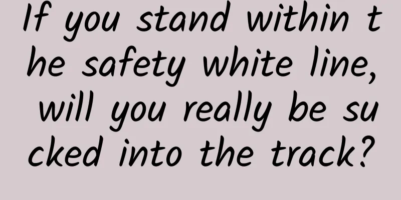
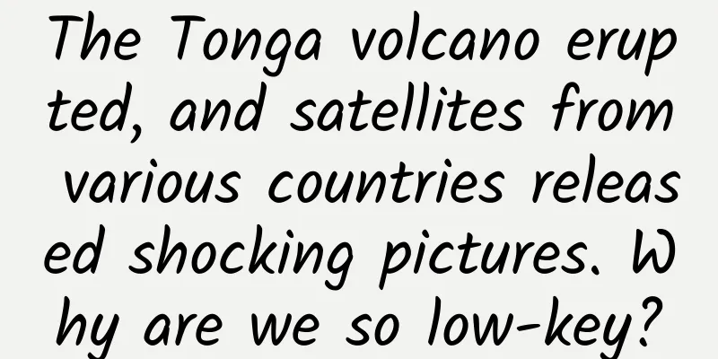
The Tonga volcano erupted, and satellites from various countries released shocking pictures. Why are we so low-key?
|
The Tonga volcano eruption caused a huge disaster to the small country of Tonga. Its volcanic ash flew into the atmosphere and drifted to the surrounding areas, which may have an impact on the world's climate in the future. Today we will not discuss the sequelae of the disaster, but only talk about this volcanic eruption. The biggest difference from the past is that the camera recorded the earth-shaking moment, and high technology brought people a shock that they could not experience in the past. In particular, numerous satellite photos reflect the technological strength of various countries, allowing people to have a bird's eye view of that shocking moment from space. The above picture was taken by the US GOES-17 weather satellite, which was positioned above the equator at 137 degrees west longitude and captured the shocking image of the volcanic eruption. The Japanese Himawari-8 satellite also captured this stunning moment. The satellite was positioned above the equator at 140° east longitude, and happened to capture the eruption of the Tonga volcano. China also has its own weather satellites, which also overlook the world from high altitudes and took images of the moment of the volcanic eruption. These images were taken by the Fengyun-4B and Fengyun-2F satellites. Comparing these pictures themselves, the images taken by our satellite do not seem to be inferior, they are very clear and well-layered, but the angle is slightly off. Why is that? To clarify this issue, we must first understand what a synchronous geostationary satellite is. Geosynchronous satellites are generally artificial satellites sent into an altitude of about 36,000 kilometers (35,786 km to be exact) above the Earth's equator. They run in sync with the speed of the Earth's rotation and revolve around the Earth once in 24 hours. In this way, it looks like the satellite is staring at one place on the Earth without moving, with a fixed bird's-eye view of about 1/3 of the Earth, and sharing the day and night with the Earth. The vast majority of the world's meteorological environment monitoring satellites are of this type. my country has launched Fengyun series meteorological satellites, including 1, 2, 3, and 4. Four Fengyun-1 satellites were launched, eight Fengyun-2 satellites were launched, four Fengyun-3 satellites were launched, and two Fengyun-4 satellites were launched. Some of these satellites have been used for experiments, while others have played an important role. The earliest satellite, FY1, was launched in 1988. Most of the early FY1 and FY2 satellites have failed. The accuracy and technical level of the later satellites are getting higher and higher. They are basically operating normally and playing an increasingly important role in the national economy and military. The Fengyun-2F satellite that took the image of the Tonga volcano was launched on January 13, 2012, and was positioned at 112° east longitude above the equator; the Fengyun-4B satellite was launched on June 3 this year, and was positioned at 123.36° east longitude above the equator. Both satellites are at an altitude of about 36,000 kilometers, monitoring changes in the meteorological environment in an area of the Earth. The American GOES-17 satellite and the Japanese Himawari 8 satellite that released the photos of the Tonga volcanic eruption are both geosynchronous orbital meteorological and environmental monitoring satellites, operating at an altitude of about 36,000 kilometers. Since they are both satellites operating at high altitudes, why are the shooting angles different? This is where the origin of the Earth's positioning coordinates comes from. In order to accurately locate every position on the earth, people draw some virtual lines on the surface of the earth, and form coordinates through the intersection of horizontal and vertical points. So that any place can be marked with a cross. These virtual lines are called the longitude and latitude of the earth. The meridian is an imaginary line on the surface of the earth that runs through the North and South Poles. These lines are longitudes. Internationally, the meridian (longitude) that passes through the original site of the Greenwich Observatory in London, England is called the prime meridian, also known as the 0-degree line. From the 0-degree line, 360 meridians are evenly drawn around the earth. These meridians are called longitudes. The North Pole is usually at the top of a globe or map, so counting from the prime meridian (0 degrees longitude) to the right is east longitude, and counting from the left is west longitude. East longitude and west longitude each divide the earth in half, each with 180 degrees, that is, the east and west longitudes intersect and overlap at 180 degrees, and the 180-degree longitude is the same meridian. Latitude starts from the equator, which divides the earth equally between north and south. The line that goes around the earth is the 0 degree latitude. The latitude is divided into 90 degrees south latitude and 90 degrees north latitude. Starting from zero degrees, going to the North Pole is from 1 degree north latitude to 90 degrees north latitude, and going to the South Pole is from 1 degree south latitude to 90 degrees south latitude. The north and south poles are 90 degrees. In order to further divide each location on the earth, such as your home, where you are standing now, the latitude and longitude below the degree is divided into minutes and seconds, 1 degree is 60 minutes, 1 minute is 60 seconds. The decimal point can also be used to divide the seconds, which can be divided to the position of an ant. For example, the location of Beijing is 116°20′ east longitude and 39°56′ north latitude, which only refers to the approximate center of Beijing. Beijing is very large, and the longitude and latitude occupy several degrees. Therefore, to determine a certain place in Beijing, it is necessary to divide it by minutes and seconds. For example, the location of Tiananmen Square is 116°23′17″ east longitude and 39°54′27″ north latitude. The symbol for east longitude is E, the symbol for west longitude is W, the symbol for south latitude is S, and the symbol for north latitude is N; degrees, minutes, and seconds can be represented by "°, ', ″". With this method of dividing coordinates, people can mark any address with longitude and latitude, and modern navigation can take you to find this place. Now let's talk about why our satellite images are the most biased. From the above animation, we can see that compared with the images taken by American and Japanese satellites, ours is also very clear, but it is just a glimpse from a distance. How come we didn't capture the front? In fact, this is mainly a matter of luck, not a problem of level and technology. The specific location of the Tonga volcano eruption was at 20°32′34.8″ South Latitude and 174°24′21.6″ East Longitude. This location is more than 20 degrees different from the equatorial latitude where the meteorological and environmental satellite is located. Now we ignore the latitude deviation and look at the longitude deviation of several satellites. The US GOES-17 satellite is positioned at 137 degrees west longitude, about 49 degrees away from the longitude of the Tonga volcano; Japan's Himawari 8 satellite is positioned at 140 degrees east longitude, only 34 degrees away from the longitude of the volcano; and China's Fengyun 4B satellite is positioned at 123 degrees east longitude, 52 degrees away from the longitude of the Tonga volcano; Fengyun 2F is positioned at 112 degrees east longitude, 62 degrees away from the longitude of the Tonga volcano. This is why all images are not completely centered. The closer the satellite is, the more centered the image will be. Our satellite is farther away from the Tonga volcano than the Japanese and American satellites, which means it is the farthest away. The earth is round, and the farther away it is, the closer it is to the horizon. Therefore, the shooting angle is slightly off compared to the American and Japanese satellites. It can be seen that whether the photo is taken correctly or not is caused by objective factors and has nothing to do with the level of technology. However, some people say that the longitude difference between the Fengyun-4B satellite and the American satellite to the Tonga volcano is only 3 degrees. Moreover, the Japanese satellite is the closest. The volcanic eruption photographed by the American satellite seems to be more shocking and clear than that taken by the Japanese satellite. Does this show a gap in technological level? As an ordinary popular science writer and not a scientist doing professional research, I cannot give an in-depth answer. So, can the satellite adjust its orbit to rush to the scene to shoot? Some friends asked, when encountering such a shocking event, can't we adjust the satellite orbit and go to the accident site for detection? From common sense, of course we can, but the cost is too high. Because the orbits of all satellites are fixed after they are launched into space, especially synchronous geostationary satellites, which are generally immobile. Satellites usually carry a small amount of fuel, which is mainly used to adjust the orbit so that the satellite can maintain the established orbit. Although the atmosphere in the upper air is extremely thin, there is still some residual atmosphere that causes resistance. In this way, the satellite will slow down and lower its orbit over time. If it does not speed up to restore the orbit, the satellite will be scrapped and eventually fall into the atmosphere and burn up. These fuels are one-time and cannot be replenished. Once used, they are gone. When the fuel runs out, the satellite is decommissioned. It costs a lot to send a satellite into space. If you use up the little fuel just to take a photo, it is undoubtedly tantamount to suicide. Of course, if something serious happened that endangered the survival of the country or even the human race, and we had to fight to the death to save it, it was not impossible to activate the satellite to change its orbit to do such a thing. But the question is, can this amount of fuel accomplish such a task? Moreover, operations like changing a satellite's orbit to a new one are not like those of a fighter jet, where one can just turn the rudder. There is no air in space, and orbit changes rely entirely on the reaction force of the jet, which is relatively slow, complicated and time-consuming. By the time the orbit change is successful and reaches the sky above the emergency, it is already too late. If we change the orbit to film the Tonga volcano eruption, regardless of whether it will succeed or not, even if we reach the volcano, the volcano will have long been extinguished, and even the volcanic ash will have drifted far away. Therefore, it is completely unnecessary and impossible to rely on geostationary satellites to change their orbits to detect such emergencies. I wonder if my friends are satisfied with my answer? Welcome to discuss, thank you for reading. The copyright of Space-Time Communication is original. Infringement and plagiarism are unethical behavior. Please understand and cooperate. |
<<: It’s scary to think about it! This is how your privacy is sold...


Recommend
Advertisements cost 680,000 yuan each, accounts sold for 178 million yuan in cash… Luo Zhenyu and Mi Meng are facing five major changes in their businesses
After Mimi Meng ’s advertising quotation of 680,0...
China releases five-year plan to become a space power. What are the space dreams of China, the United States and Europe?
On January 28, 2022, the State Council Informatio...
Don’t listen to the official, the reasons and solutions for the rapid battery drain of mobile phones are here
In winter, due to the low temperature, the activi...
Can't you learn Durex? Because you don't understand these 6 marketing ideas...
poet? Joke teller? Emotional expert? A veteran in...
He overcame more than 80 difficulties and laid the foundation for China's modern bridges
bridge Your browser does not support the video ta...
Hu Q&A: Are the oil drops in soup necessarily round?
Chili oil in hot pot and sesame oil in egg drop s...
Guangxi welcomes the heaviest rainfall of "Dragon Boat Water"! Beware of secondary disasters after the rain
According to the Guangxi Zhuang Autonomous Region...
The State Post Bureau calls for couriers to be allowed into residential areas. How to pick up takeout and express deliveries during the epidemic?
To prevent the spread of the epidemic, many commu...
Can Apple Watch use the same charger as iPad?
It has been more than three months since Apple of...
How much does it cost to rent a server in Chongqing for a month?
What is the price for renting a server in Chongqi...
Close iOS 8.3 verification iOS new version system occupancy rate exceeds 40%
On Tuesday, Apple quietly closed the verification...
Danger! These common plants are "highly poisonous"! Some people actually eat them...
Expert of this article: Shi Jun, PhD in Botany, m...
The 5-year-old iPad is at a crossroads. Where should it go?
On April 7, Apple has launched the classic tablet...
Marchionne intends to spin off Jeep and Ram brands to form independent companies
According to foreign media reports, FCA CEO Sergi...