
Why did ancient civilizations build cities in forests?
|
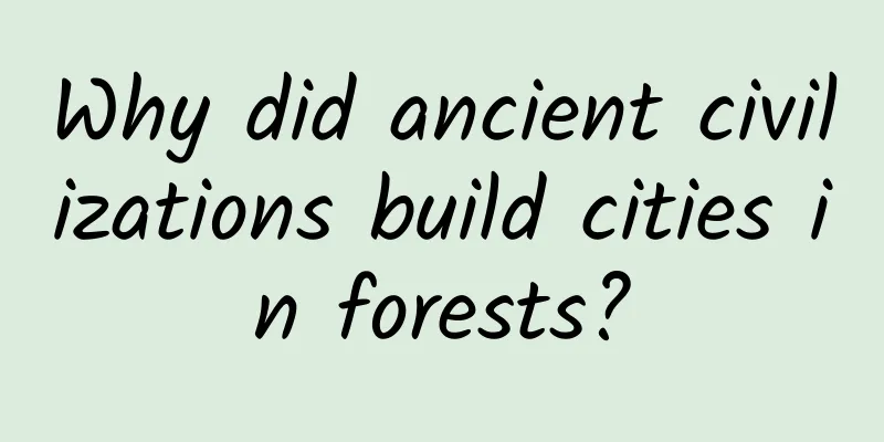
The temple of Ta Prohm in Angkor Wat, Cambodia, built in the 12th century. © Mark Croucher Leviathan Press: In the movie "Player" I watched a few days ago, at the end, the protagonist lives in a virtual world where forests and cities are organically integrated, and suspended vehicles and long-necked dragons travel on the streets without interfering with each other. The main creative team of the movie obviously wants to depict the appearance of a beautiful world with the coexistence of forests and cities. There is no doubt that the modern civilization represented by high-rise buildings is not the "beautiful" scene in their minds. Why are we so fascinated by forests? In addition to the beautiful scenery and fresh air, there is probably a sense of guilt as a member of the human race for participating in the destruction of nature. When Europeans first arrived in tropical regions of Asia, Africa, and America, the “deceased cities” of the jungle captured their imaginations. From the Lost City of Z to El Dorado, the desire to find ancient civilizations and treasures in the treacherous tropical jungles has driven countless ill-fated expeditions. This obsession with tropical forest cities has permeated the popular mindset of Western society, with countless films, novels and computer games featuring overgrown ruins as the backdrop for fear, exploration and deadly challenges. Running through these works is the idea that all ancient cities and nations in the tropical forests are doomed, because the most resilient parts of the tropical forests are the villages inhabited by hunter-gatherers, and that poison vines and towering trees, or in The Jungle Book’s case, a pack of noisy monkeys, will ruthlessly bury human achievements in that suffocating green. This view is echoed by many books and films that focus on the fall of mysterious societies such as the ancient Maya. The crumbling stone walls, empty but magnificent buildings and abandoned streets left behind by tropical cities seem to warn that our current way of life may not be as safe as we think. For a long time, Western scholars have held very similar views on the potential of tropical forests to form ancient cities. On the one hand, intensive agriculture, which is considered necessary to promote urban development and promote the number of social elites, can hardly develop in the moist, acidic and infertile soil conditions of tropical forests. On the other hand, natural disasters are inevitable in the rubble-covered tropical regions of North America, Central America, South Asia and Southeast Asia. The film Apocalypto (2006) is set in the ancient Mayan civilization of the Yucatan Peninsula in Mexico. © Tumblr As the population grows, people cut down forests to build large buildings and develop agriculture on infertile land, resulting in frequent natural disasters such as mudslides, floods and droughts, and the challenges faced by tropical cities are increasing. It’s not easy to overturn these stereotypes. First, large-scale, long-term fieldwork is difficult to conduct in tropical forests. Dense vegetation, malaria-transmitting mosquitoes, highly toxic plants and animals, and heavy rains make it difficult to find and excavate ancient city centers. The use of organic materials instead of stone as building materials has made the task even more arduous. As a result, research on ancient tropical cities has lagged far behind similar studies of Mesopotamia, Egypt, and the river valley civilizations of East Asia. However, many tropical forest societies have found highly successful ways to grow food, even under the most challenging conditions, enough to feed large populations and maintain social structures. The application of the latest technologies on land and in the air over the past 20 years of archaeological exploration has cleared many obstacles for us and provided new and more valuable research. The Mayan ruins of Kabah in the Yucatan Peninsula. © Witold Skrypczak/Getty Images Although the Classical Maya and Khmer empire of Cambodia were prosperous societies of the time, pre-colonial tropical cities were the most widespread urban landscape in the world before industrialization, far more prosperous than ancient Rome, Constantinople (now Istanbul), and some ancient cities in China. Ancient tropical cities seem to have an amazing capacity for resilience, sometimes outliving industrial colonial urban networks in similar environments by centuries. They often face multiple obstacles and have had to constantly reinvent themselves to cope with a changing climate and make better use of their surroundings. But at the same time, they have also opened up new models of urban appearance. These ancient cities, with their widespread presence, integration with nature, and interweaving of food production with sociopolitical functions, have caught the attention of 21st-century urban planners seeking to transform tropical forests into the world’s fastest-growing populations. As with the word "agriculture," Westerners tend to have a narrow concept of "city." In their minds, cities are densely populated areas, home to administrative and political elites, bustling with trade and manufacturing, and fed by vast farmlands and pastures far from the cities. This view does not seem to apply to cities in tropical forests. There, the fragmented distribution of farmland, pastures and dense settlements will cause rapid deforestation and soil erosion, which will eventually lead to severe famine and the collapse of social systems. Therefore, if such seemingly "compact" cities appear in tropical regions - such as the Classic Maya in southeastern Mexico, Guatemala, Belize, western Honduras and El Salvador - scientists tend to believe that these cities exist far beyond the carrying capacity of tropical forests and will eventually lead to deforestation and popular rebellion. Maya cities began to form around 800 B.C. Monumental stone buildings and writing began to appear in major political centers. People were ruled by kings and ate maize, beans, and squash, the staple crops of North and Central America. But it was during the Classic period that Maya society really flourished, especially in the southern lowlands (including northern Guatemala, Belize, and southeastern Mexico). Between 250 and 900 A.D., more cities, monuments, and inscriptions appeared as the population grew. Large cities such as Tikal and Calakmul had populations of up to 120,000. Mayan temple ruins in Tikal, Guatemala. © Domingo Leiva/Getty Images/Flickr RF While the soil in many of these cities is particularly suitable for growing corn, there is a problem: rainfall is erratic throughout the year, and due to geological reasons, it is often challenging to obtain or store precious water during dry months. Many scholars believe that during the late Classical period, between 800 and 900 AD, a massive drought in the southern lowlands nearly destroyed the ecosystem there. From this perspective, many large cities and their political classes clearly went too far, cutting down trees to build monuments and growing corn on a large scale on infertile land. When drought came, people were helpless to survive in a land that had been transformed beyond recognition. As a result, people no longer trusted social elites, construction was forced to stop, famine ensued, and the people of the Classical period began to flee. The story of the Classic Maya has been around for a long time. However, what is shocking is that even in the famous Maya central cities of Copán and Tikal, the population was relatively dispersed. In terms of urban planning, unlike the model of inner circle political center and outer circle cultivated land, the farmland in Maya cities is very scattered. They do not spread outward in a radial manner from a certain point. A recent study shows that Tikal is an urban network consisting of moats, residential areas, reservoirs and pyramids, extending from a hill to a radius of 200 kilometers. © Pikist Groundbreaking aerial surveys have yielded similar findings. In nearly all samples, what the scientists observed were not nascent cities but rather ensembles of dispersed agricultural landscapes, residential areas, causeways, and complex, interconnected systems of dams, reservoirs, cesspools, channels, and wetlands that could sustain a thriving population even in the driest seasons. As Lisa Lucero, a professor of Mayan studies at the University of Illinois, puts it: “The Classic Maya understood the importance of water and fertile soil, which was distributed in large and small areas, so that agriculture was also scattered. This low-density urban planning seems to be a very reasonable innovation.” The Classic Maya economy was also more diverse and complex than is often assumed. In addition to staple crops, the cultivation of avocados, pineapples, sunflowers, tomatoes, and cassava increased the dispersion of settlements and lifestyles, archaeobotanists say. The Classic Maya also raised wild turkeys and deer for animal protein. Scientists have shown that it was these diverse “forest gardens” that supported the growth of these cities. Based on ethnographic records and studies of Maya society, we have found that this farming method, called milpa (kol in Yucatec), involved the cultivation of multiple crops and the movement of farmland, which allowed the land to rest and adjust. We also found that the Classic Maya did not develop agriculture indiscriminately, but rather selected areas with fertile soil for cultivation, which made their farmland system appear to be winding and extending along rivers and hillsides. They even began to grow special plants in reservoirs, such as water lilies. These plants are very sensitive to water quality and can only survive in clean water, which requires people to monitor changes in water quality at all times to prevent the spread of diseases. The temple of Ta Prohm in Angkor Wat, Cambodia. © Stewart Atkins (visualSA)/Getty Images Maintaining a large population in the highly seasonal tropics was difficult, as water was often scarce, and this took a heavy toll on many parts of the Maya "heartland." Detailed studies by climate scientists show that droughts became more frequent starting around 800 AD. Some studies also show that deforestation, at varying levels in hundreds of Maya urban centers, exacerbated water shortages to varying degrees. In the southern lowlands, surface water was hard to find even in the best of times, and agricultural yields in many cities, including Tikal, declined year after year, leading to increasing hunger and pressure to survive. As resources became scarce, violence between cities became more frequent. Kings claimed close connections to the gods, but the source of their political power was often questioned in times of drought and crop failure. As people realized that building pyramids and palaces did not bring them any additional income, they went on strike. The ceremonial centers became ruins and were abandoned in the southern Maya lowlands, awaiting the arrival of scientists centuries later. This certainly looks like a swift and complete disaster. But the truth is more complicated. Given their long-standing understanding of ecosystems, coordinated economics, and water management (which is often lacking in 21st century urban system planning), was a widespread disaster really possible? In fact, Maya cities like Chichén Itzá flourished into the Late Classic period (900-1520 AD), even during the birth of Spain. New sources of fresh water were discovered, such as sinkholes, lakes, and rivers. In many areas, independent farmers were a key part of the Classic Maya urban system, although they were few and far between. In the El Pilar area, the ceremonial center of Tikal, agricultural communities managed forest gardens that would bear witness to the rise and fall of Tikal. This diverse agriculture survives among the indigenous Maya groups that still occupy large tracts of the region today. These groups engage in traditional manufacturing and landscape management. Much like our own society today, urban archaeologists tend to focus on the more eye-catching remains. When tropical cities are built on vast networks of independent farmers and artisans, the extraordinary resilience inherent in the foundations of this system is overlooked. Perhaps the most famous of these ruins is the Greater Angkor region of Cambodia, where hordes of tourists flock every year to the temple complex of Angkor Wat, which was the religious center of the Khmer Empire in the 12th century AD. However, few realize that this magnificent temple was just a small part of a once vast society. Urban settlements began to appear in the region around 1000 BC. By the 9th century AD, the new capital of the Khmer Empire on the Southeast Asian mainland, Yaśodharapura, was formed in the Angkor region. There were large reservoirs, a series of walled administrative palaces, and Buddhist and Hindu temples, which flourished until the 14th century. For a long time, archaeologists focused their attention on impressive, densely packed ceremonial centers such as Angkor Thom and Angkor Wat. But then two things happened. First, starting in the 1990s, French archaeologist Christophe Pottier and his local collaborators conducted decades of field work, identifying many architectural features, large and small, across the greater Angkor area. The ruins of Ek Balam in Mexico's Yucatan Peninsula. © Harry Kikstra/Getty Images Then came a new approach: light detection and radar ranging. Damian Evans, one of the leading experts in applying this approach to tropical archaeology, said: "Lidar allows us to exclude interference factors such as vegetation. A laser scanner attached to an aircraft scans the terrain with laser pulses and collects billions of points. Some laser beams will be reflected back by the trees, but others will pass through the branches. Then we can model and understand what is underneath the vegetation." What they found at Angkor was simply incredible: more than 1,000 square kilometers of habitation had once existed alongside 3,000 square kilometers of transformed landscape. This made Angkor the most extensive human settlement on Earth before the industrial age, larger even than cities like Paris today. It completely overturned our understanding of how this ancient metropolis worked. LiDAR image of Angkor Wat taken in 2012. © agefotostock/Alamy Like the sprawling urban settlements of the Classic Maya, which were not simply composed of dense ceremonial centers, Angkor Wat is another striking example of low-density urban sprawl. Radar sweeps across the spacious courtyards of Angkor Wat’s ceremonial center show that people once lived in piled-wood houses within stone walls. Countless large earthen mounds, small shrines, and rice fields extend upward from the boundaries of the Angkor Wat site, across the lowlands and into the mountains. The residents of Angkor Thom knew how to make use of the vast tropical forests and fields, picking palms, vegetables and fruits in orchards and retaining a certain range of forest cover. They raised fish in rivers and ponds, and raised pigs, cattle and chickens in the busy streets. The study shows that to support the growing population and animal population, a vast network of waterways and reservoirs fed by tributaries was built. As expected, this sprawling metropolis did put pressure on the tropical landscape. There was clear evidence of deforestation and soil erosion in many areas, although the impacts were relatively diffuse. The Angkor era eventually came to an end. In the late 14th century AD, increasingly extreme climate change between droughts and floods destroyed much of the water network, severely affecting agricultural output. In urban areas, people moved out of palaces and temples as independent farmers saw no reason to remain under the umbrella of the political elite. However, the city did not collapse. What happened next is even more interesting. The rulers moved the capital to the new city of Phnom Penh. At the same time, farmers moved to small towns along the Mekong River and Tonlé Sap Lake, where there was a more stable water supply. Like the Classic Maya, the Angkor ruling system eventually failed, especially in a region with severe seasonal rainfall and a harsh climate. But the Angkor elites did not want to compromise, and they came up with a new strategy - moving the center of power, while the farmers were left on the land that had long provided food for the rulers, although they also tried to find more suitable areas for farming and grazing. Once we pass through the overgrown walls of the temple, a highly restored, vast urban life system, represented by Angkor Thom, appears before us. Compared to Cambodia's seasonally dry tropical forests, the Amazon Basin's rainforests present another challenge for urban societies. In fact, some archaeologists and anthropologists believe that it is almost impossible to build cities and develop agriculture in hot, humid, acidic (and often flooded) land. After all, there are only a few scattered indigenous villages in the rainforest, and there is no obvious social hierarchy. In other words, all the actions we are taking today to expand infrastructure and develop agriculture and animal husbandry will cause immeasurable harm to the environment. However, a growing body of research by archaeologists, anthropologists, environmental scientists and indigenous communities is revealing a wealth of garden city landscapes, such as earthworks, clustered structures and roads in the Amazon. (www.nature.com/articles/s41467-018-03510-7) In and around the Xingu River, settlements peaked between 1250 and 1650 AD, just before the arrival of Europeans. Interestingly, their patterns closely resemble the agricultural-based, low-density urban forms of the Classic Maya and Greater Angkor. In almost every case, the large central town is surrounded by massive wooden walls and ditches, connected to a number of satellite villages by paths carved through the forest. Rather than large-scale deforestation, these settlements are separated by intact forest belts, which allow for better management of orchards, fish and freshwater turtle farming, and larger fields for growing cassava and corn. The lost city of Ciudad Perdida in Colombia. © Maxime Dube/Alamy Stock Photo Years of research have also documented a series of similar urban settlements on Marajó Island, at the mouth of the Amazon. The population grew in size and density in the 14th century, peaking at 100,000 people. Analysis of human remains suggests that, like the garden cities of the Xingu River, the inhabitants of Marajó Island and the nearby Maracá region ate a variety of plants, hunted and fished, used the rainforest to store water, or cultivated some cassava and corn in more open areas. Ultimately, these low-density, agriculture-based “Amazonian” urbanizations may have resulted in a pre-European population of 20 million in the Amazon. Given that the population of Europe in 1492 was estimated to be between 70 and 88 million, this means that a significant portion of the population lived in an urban form that was different from the way we think of cities. Not all ancient cities in tropical regions look like the ones described above. They are certainly rarer and more likely to disappear than more dense urban forms. However, the examples above provide important insights into the tropical forests of the past, showing us the possibilities and creativity of ancient cities there. The rational use of forest wildlife, fishing in abundant freshwater environments, and the cultivation of mobile crops in open areas all provided ample conditions for the rise of some of the largest cities in the pre-industrial era. Dispersing the growing population into satellite cities has reduced the impact of human activities on tropical biodiversity and soil quality. Of course, risks remain, especially in seasonally dry forests, where deforestation and extreme weather events will sharply reduce people's ability to survive. However, some very resilient cities have been able to survive for a long time - Angkor Wat and several classical Maya cities have lasted for more than 500 years. The model of “agriculture-based, low-density urbanization” remains relevant to urban planners in tropical regions today, who want to build green cities to ease the tensions between pressing environmental protection needs, political and cultural infrastructure construction, and growing urban populations. There are still many, many cities built by former colonial states and empires in the tropics. Quite a few, such as the Amazon and the Postclassic Maya, continued to thrive during contact with Europeans. They were even often admired by European visitors. Why, then, do we tend to think of tropical forests as inhospitable to large populations and high food production? Why is it commonly assumed that only ruins and small, isolated indigenous tribes are suitable here, rather than the cities, settlements, and monuments that will stand the test of time? It’s time to rethink. —————— Adapted from Jungle: How Tropical Forests Shaped the World – and Us, by Patrick Roberts, published by Viking Books on July 1. By Patrick Roberts Translation/Sodium Potassium Proofreading/Rabbit's Light Footsteps Original article/www.theguardian.com/news/2021/jun/22/the-real-urban-jungle-how-ancient-societies-reimagined-what-cities-could-be This article is based on the Creative Commons License (BY-NC) and is published by Sodium Potassium in Leviathan The article only reflects the author's views and does not necessarily represent the position of Leviathan |
>>: No one is better than this cat at slacking off!


Recommend
Cold Start | How I ignited Huajiao Live without spending a penny
At the end of 2015, the night when Wang Sicong po...
11 marketing techniques preferred by top marketers, each one is a killer!
Many years ago, Shi Yuzhu, the legendary marketer...
Why are those medicines that have grown with us gradually disappearing?
Recently, the State Drug Administration issued th...
How to conduct data analysis in SEM promotion?
When an account accumulates a certain amount of d...
Yan Jie 7 steps to get a celebrity back
Yan Jie's 7 steps to get a celebrity back Res...
It rained in many places when Jam Hsiao proposed. Is the “Rain God” really that powerful?
At 20:15 on June 27, singer Jam Hsiao, known as t...
From IOUs to smart logistics, why is JD.com's big data more promising than AlphaGo?
A round of Go competition between man and machine...
Don’t throw away your unused iPhone. Use Carplay to build a smart car
Apple Carplay was launched a long time ago, but i...
Nintendo's next-generation console will use Android system
June 1st news, we still know very little about Ni...
After interviewing more than 50 UI designers, I summarized these job hunting skills!
Some time ago, the company was recruiting UI desi...
Can't resist the "sweet temptation"? Why not give it to "red, orange and green"?
This is the 4582nd article of Da Yi Xiao Hu News ...
What is this? Tens of thousands of little penguins in Antarctica line up to jump off a 20-meter-high ice cliff
Tens of thousands of emperor penguin babies stagg...
1000 top landing pages, 5 conversion rate optimization tips
Conversion is the key factor in paid promotion . ...
Google's new self-driving car skill: three-point turn
There is a test item in the US driver's licen...
From closed to open, BYD plummeted 173% and transformed itself in the crisis
BYD has been having a hard time recently. BYD'...