
Satellite cloud images help you understand the weather: What does a "front" look like? What is an "upward cloud top"?
|
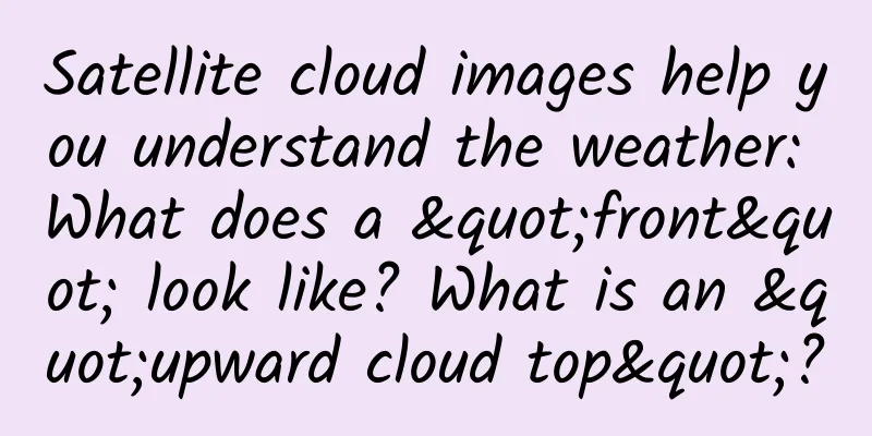
Front Does the term “front” look very professional? In fact, it is the interface or transition zone between two air masses with different physical properties such as temperature and humidity. In simple terms, it is the interface between cold and warm air masses. The intersection of the front and the ground is called the front line, or simply the front. The length of a front can generally range from several hundred kilometers to several thousand kilometers, and can extend more than ten kilometers in the vertical direction. According to the thermodynamic classification method, if a cold air mass pushes a warm air mass forward, it is called a cold front; otherwise, it is a warm front. If the cold and warm air masses are of equal strength, it is called a quasi-stationary front. If a cold front catches up with a warm front, an occluded front will form. Without further ado, maybe you will understand it by combining it with satellite cloud images! The arrow in the figure points to the cold front. What should I do if I see a cold front? In winter, the cold front is strong and brings cold waves; in summer, the cold wind is weak and brings thunderstorms. Attention! When a cold front passes through, the temperature difference between two places in the same province can reach more than ten degrees. Remember to add or remove clothes appropriately! Up to the top As a characteristic of severe storms, upthrust cloud tops are associated with updrafts that clearly penetrate the equilibrium altitude (i.e., the altitude of the broad thunderstorm cloud tops). In the visible light cloud images of Fengyun satellites, upthrust cloud tops appear as bright bulges, like "little bumps". Bright bulges above the cloud tops can be seen at locations A, B, and C in the picture. What should I do if I see the sky heading up to the top of the clouds? The appearance of upthrust cloud tops indicates the presence of strong updrafts in the area and a high likelihood of severe weather. Roller Cloud Also known as wave clouds, they are horizontal, tube-shaped clouds. Wave clouds are created when stable air is disturbed, causing the air to move along the disturbance, like waves in a pond. This disturbance is usually created when cold, dry air from a moving cold front collides with a relatively stable area of warm, moist air. If the stable layer of air is moist, clouds form on top as the air flows upward. When the air flows downward, the clouds evaporate. The alternating absence and presence of clouds is what creates the wave effect. (Photo/Text by Jia Xu and Xie Yifei) The arrow in the picture points to the roller cloud. This type of cloud system mainly occurs over the sea and may indicate that a squall line or thunderstorm is approaching. Once you see it, please return to a safe place in time to be on the safe side. |
<<: 167 flights a year! This professor's belief ignites countless people
>>: Infected and in quarantine? Keep this list of items to keep!


Recommend
Type-C interface has taken over the market, so we no longer have to look for loose wires all over the house?
Editor: Sunny Morning Recently, the European Unio...
Is it safe to eat the Basa fish that costs only a few dollars a pack in the supermarket?
Have you noticed that restaurants love to use Bas...
Juefei Technology's strength is listed in the "2020 China New Infrastructure Industry Innovation List"
On August 18, the "2020 China New Infrastruc...
From 0-1, how to transform commercial product operations?
The author of this article selected several job r...
UDesign - [Jia Jia Jia] A Beginner's Guide to Color Matching for Commercial Illustrations
UDesign - [Jia Jia Jia] Commercial Illustration C...
Why is the phone still not easy to use even though it has such a high performance score?
Is the performance of the mobile phone good? Just...
Implementing Audio Graphs in SwiftUI
Preface Graphs are one of those complicated thing...
Facebook adds new open source features for Android programmers and significantly modifies Buck!
Facebook is improving its open source performance...
Zhihu information flow: a "small trend" in advertising promotion and marketing in 2019!
On the first day of 2019, Luo Zhenyu's New Ye...
There are five key indicators for private domain traffic operation
This article sorts out the five key indicators an...
International Amyloidosis Day│ No more than 10 cases per million people! What is the rare "amyloidosis"?
Systemic light chain (AL) amyloidosis is a rare d...
When you are discussing whether XBOX ONE X can be unlocked, it can also stimulate these two industries
“Can the Chinese version of XBOX ONE X be unlocke...
The underlying logic of Douyin e-commerce product selection
Anyone who has worked in e-commerce may have hear...
QQ update! The new function is simple and crude, no longer worry about voice being eavesdropped
Report! Tencent is here again, bringing the lates...
Why did Apple launch the gold version of the Apple Watch at a sky-high price?
Benedict Evans, an analyst at venture capital fir...