
Satellite cloud images help you understand the weather: Do you know what convective clouds look like?
|
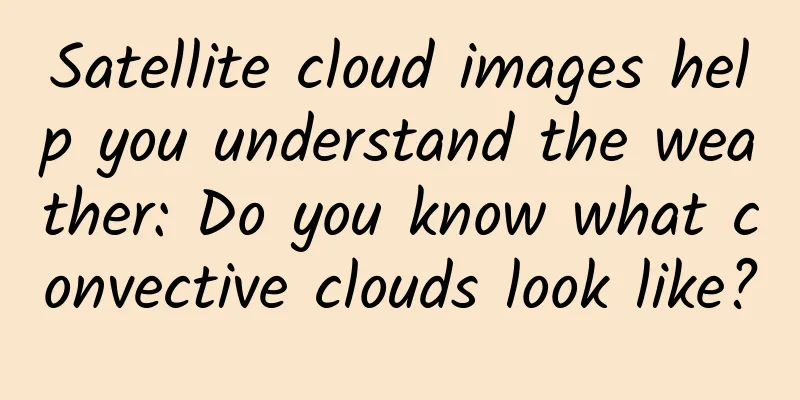
Small convective cloud Convective clouds are clouds formed by convection. When the atmosphere is in an unstable state, with cold air on top and warm air on the bottom, the warm air in the lower layer will rise, thus forming convection. The temperature of the rising warm air will continue to decrease, and when it reaches a certain height (condensation height), water vapor will condense to form clouds. This type of cloud is a convective cloud. If the convective clouds are distributed in clusters, they are called convective cloud clusters. Arrows point to small convective clouds. What should I do if I see convective clouds? If the convective clouds are scattered, you don't need to pay too much attention to them. If the convective clouds gradually gather and increase in number, you need to pay attention, because severe convective weather may be coming! Heavy precipitation may occur. fog Want to know how to tell whether it is fog or cloud from satellite cloud images? First of all, we need to understand what fog is. Fog is a liquid weather phenomenon composed of tiny water droplets or ice crystals suspended in the air near the ground. It is the product of condensation (or sublimation) of water vapor in the air near the ground. Fog has obvious daily changes. The temperature is relatively high during the day, and the air can hold more water vapor. However, at night, the temperature drops, and the air's ability to hold water vapor decreases. Therefore, some of the water vapor will condense into fog. Fog is usually most likely to appear from midnight to early morning, and will quickly dissipate after sunrise. The arrow points to the "branch-like" mountain fog. What should I do if I see fog? Pay attention to whether there are any warning signals in the local area, and drive slowly when visibility is low. Wave Cloud System Wave clouds are orographic clouds formed in air currents crossing hills or mountains. They are several kilometers to tens of kilometers long and present light and dark, neatly arranged parallel cloud bands, like ripples. This is caused by the vertical fluctuations of the atmosphere, the wind direction is orthogonal to the mountain ridge, the atmospheric stratification is stable, and the cloud bands are parallel to the mountain ridge. The picture shows a wavy cloud system. What should I do if I see wavy clouds? This type of cloud system will not produce any violent weather processes, it just has a special shape. |
<<: 60 times the limit! Well-known yogurt was investigated... How to choose yogurt?
>>: How do colored diamonds come about? They lose color after being polished!


Recommend
How effective is information flow advertising? What are the advantages of information flow advertising?
What is information flow advertising ? "Feed...
Electric Technology Car News: Looking beyond the surface and into the essence, is Zotye’s Damai X7 really not a copycat?
At present, the Dalmai X7 offers 1.5T, 1.8T and t...
With an annual output value of nearly 2 billion, the "French foie gras" you eat may be produced in this small county in China
Goose liver, as an offal food, is not unfamiliar ...
One of the deepest holes in the world: It took more than 10 years to drill 12 kilometers and is the third deepest in the world
In the last century, the Soviet Union created man...
Change your wealth beliefs and live a rich life Lai Qiukai's wealth thinking upgrade course [Complete] Baidu Cloud Download
When you feel that your time is worthless, you ar...
The International Space Station is about to be decommissioned. Where will it go? Will it fall or be recovered?
Although the service life of the International Sp...
Advice and teachings that impressed programmers
In one’s life, of course, there is plenty of time...
6 audio lessons on high emotional intelligence and interpersonal skills in government agencies
Introduction to the 6-lesson audio course resource...
Is the franchise fee of Zhumadian Movie Mini Program high? List of franchise fees for Zhumadian Movie Mini Program
How much does it cost to join a movie mini progra...
6000 words to explain the underlying logic of operations
I believe that many of my friends will feel that ...
Can’t do these 5 things? I advise you not to invest in information flow!
According to the latest data from iResearch MUT, ...
How did you get your first 1,000 users? Start with the stupid things!
The story begins with hotmail. In 1996, two engin...
Why is the Yellow River named Huang? A brief discussion on the origin of the name "Yellow River"
The Yellow River, which has been surging for thou...
In which field is it easier to make short videos? Which industries are short videos suitable for?
If you want to shoot short videos , choosing a go...
The neglected "egg beater" - the life of Darrieus wind turbine
Author: Cheng Mingchen The article comes from the...