
How does the Southern Xinjiang Loop Railway encircle my country's largest desert?
|
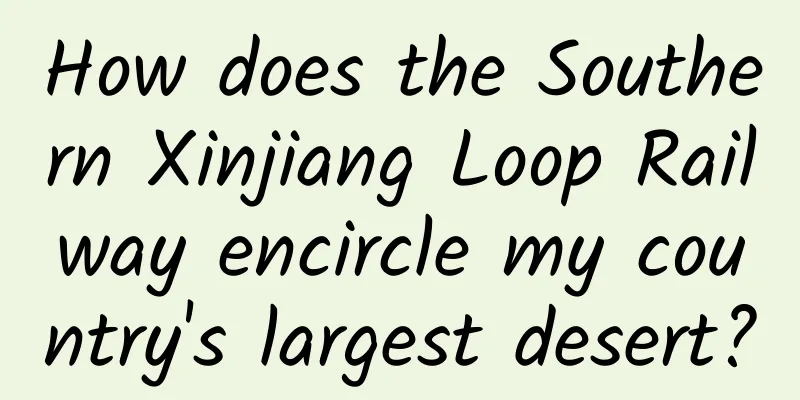
Recently, the Hotan-Ruoqiang Railway in Xinjiang (abbreviated as the Hotan-Ruoqiang Railway) was officially opened, marking the formation of the world's first desert railway loop, the Taklimakan Desert Railway Loop. The Hotan-Ruoqiang Railway is about 825 kilometers long and is connected to the Geku Line, Southern Xinjiang Line, and Kahe Line, which have already been opened, making the "Southern Xinjiang Loop Line" officially a closed loop with a total length of 2,714 kilometers. In the future, the route from Southern Xinjiang will be shortened by more than 1,000 kilometers compared to before. The "South Xinjiang Loop" railway surrounds the Taklimakan Desert, the world's tenth largest desert, covering an area of 377,000 square kilometers. Speaking of the "Southern Xinjiang Loop" railway, let's take a look at the Tarim Basin and the Taklimakan Desert. The Tarim Basin is surrounded by the Tianshan Mountains, the Pamir Plateau, the Kunlun Mountains, and the Altun Mountains in a counterclockwise direction. The mountains on the east side are slightly lower, and there is only a valley about 70 kilometers wide that connects to the Hexi Corridor. The Tarim Basin is elliptical, about 1,500 kilometers from east to west, about 600 kilometers from north to south, and has a total area of about 555,900 square kilometers. The Tarim Basin has an altitude of between 800 and 1,300 meters, with high terrain in the west and low terrain in the east. Lop Nur in the east is the lowest point in the basin and also the center of salt accumulation, with an altitude of about 780 meters. The edges of the Tarim Basin are foothills, Gobi Desert and oasis (alluvial plain), the middle part is the Taklimakan Desert, and it is 2,000 to 4,000 kilometers away from the Pacific Ocean, Indian Ocean, Atlantic Ocean and Arctic Ocean. As the Tarim Basin is surrounded by high mountains, it is difficult for the humid air currents from the ocean to reach it, and the Taklimakan Desert has almost no rain all year round. The average annual rainfall is 15-20 mm, and the average annual evaporation is as high as 2500-3400 mm. The Taklimakan Desert is the largest desert in my country and ranks tenth in the world. It is about 1,130 kilometers long from east to west, about 400 kilometers wide from north to south, and covers an area of about 337,600 square kilometers. One-third of the days in the Taklimakan Desert are windy and sandy throughout the year, with an average of 60 days of sandstorms per year and strong winds reaching 30 meters per second. The wind direction and speed in the Taklimakan Desert are unpredictable, and the area of mobile sand dunes accounts for 85% of the total desert area. In addition to the commonly seen sand ridges, crescent-shaped dunes and dune chains, there are also complex dune chains, complex longitudinal sand ridges, pyramid dunes, fish-scale dunes and dome-shaped dunes. The Hotan-Ruoqiang Railway starts from Ruoqiang Station of the Golmud-Korla Railway in the east, runs westward along the northern foot of the Kunlun Mountains and the southern edge of the Taklimakan Desert, and ends at Hotan Station of the Kaholi Railway. It has a designed speed of 120 kilometers per hour and is a national Class I single-track railway. There are 22 stations along the entire Hotan-Ruoqiang Railway, 11 of which provide passenger services: Hotan Station, Lop Station, Cele Station, Yuquan Town Station, Yutian Station, Minfeng Station, Nantun Station, Jinshan Station, Qiemo Station, Washixia Station and Ruoqiang Station. About three-quarters of the Hotan-Ruoxi Railway crosses deserts and Gobi, and the windy and sandy sections of the entire line are more than 500 kilometers long. On the rails, trains are speeding; under the roadbed, rows of plants such as Haloxylon ammodendron, Calligonum mongolicum, Tamarix chinensis, Tamarisk, and Populus euphratica accompany the trains. A nearly 300-kilometer green windbreak and sand-fixing belt has been built along the Hotan-Ruoxi Railway, with lush plants forming a green Great Wall to protect the Hotan-Ruoxi Railway. The opening of the Hotan-Ruoqiang Railway saves the cost and time of cargo transportation along the line, and will effectively drive the economic development of southern Xinjiang. (Statement: This article is from Map Emperor. It is reproduced only for learning and communication, not for commercial purposes. All reproduced articles will indicate the source. If the original author of the article or photo has any objection, please contact us in the background and we will quickly process or delete it. Thank you for your support.) |
<<: It can "breathe fire"! Be careful when buying it
>>: Shanghai Synchrotron Radiation Light Source takes pictures of molecules


Recommend
Whenever I talk to others about my work, I always say “a glimpse of the leopard through the tube can reveal a part of it” (Part 1)
Produced by: Science Popularization China Author:...
Why can many animals walk as soon as they are born, but humans can't?
Audit expert: Mao Xinmei Chief Physician of Pedia...
How to place Xiaomi information flow? I summarized the 4-step method of creative optimization that affects CTR
Users are paying more and more attention to the e...
This lizard, named after the snake monster, has the ability to walk on water.
In the martial arts novel The Legend of the Condo...
Are bigger planes safer? The higher you fly, the greater the risk? These "10 dark minutes" are a matter of life and death...
Expert of this article: Lin Wenjie, engineer, sen...
What does SEO strategy mainly include?
What does SEO strategy mainly include? A few year...
30 Thinking Games to Ignite Your Smart Brain Video Course Baidu Netdisk Cloud
30 Thinking Games to Ignite Your Smart Brain Vide...
How to plan a screen-sweeping event, 4 tips!
How to plan a screen-sweeping event? Just read th...
The products exposed on 315 are really deadly if they are fake! Don’t take it lightly!
A type of glass called fireproof glass was expose...
Carbon dioxide: You can conquer it with shellfish! Can shellfish farming also fix carbon?
Problems such as global warming and extreme weath...
Talk about the user growth system: A brief analysis of the user growth system of "KEEP"
1. What is the user growth system? The user growt...
5 effective methods to gain insight into user needs!
First of all, returning to the logic of the “valu...
How did the little cricket change from a "cricket" to a "food"?
Crickets, this tiny insect, have been closely con...
Can WeChat groups be rented out? It is true that you can make money lying down, but don’t do it.
[[312116]] Since WeChat was launched in 2011, pay...
“Twenty Thousand Leagues Under the Sea”: Why did the country’s first underwater data center choose to sink to the bottom of the sea?
Author: Zhang Yuzhi A recent news (November 24, 2...