
What is the brushed cloud? Clouds have names, and if you don't know them, the clouds will be sad!
|
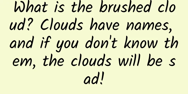
Clouds are a testimony to the beauty of the world and one of the most common atmospheric phenomena. However, "cloud" is just a general term like "bird" or "flower". Each cloud has its own name. If you can recognize clouds with wisdom , I think it is really - Thai pants spicy! How can a beginner quickly get started and identify various clouds ? Take this guide and become a cloud identification master next time you go out. In this article you will find: Clouds also have their own classification system. Common clouds can be divided into three families and ten genera . The three families are low clouds, middle clouds and high clouds; the ten genera are cumulonimbus clouds, nimbostratus clouds, stratus clouds, cumulus clouds, stratocumulus clouds, high-level clouds, altocumulus clouds, cirrus clouds, cirrostratus clouds and cirrocumulus clouds. To quickly identify cloud species, you can focus mainly on weather conditions, cloud shape and color. Simply remember the names of some beautiful clouds! What is cloud? Clouds are a collection of water vapor condensation, composed of tiny particles of liquid water or ice or a combination of both. They are suspended in the atmosphere and do not touch the ground (those that are attached to the ground are called "fog"). Similar to the classification system of "kingdom, phylum, class, order, family, genus, and species" in biology, clouds can also be divided into cloud families (Levels), cloud genera (Genera), and cloud species (Species) from broad to fine. Common clouds basically belong to the following three families and ten genera: Three families and ten genera of clouds. Shallow convective clouds usually refer to clouds whose "height" in the vertical direction is smaller than their "width" in the horizontal direction. Such clouds rarely produce rainfall. Once the "height" is equal to or even larger than the "width", they develop into deep convective clouds, which are very likely to produce rainfall and even develop into severe convective weather. These three families and ten genera are divided according to the most basic and obvious properties of clouds. Understanding these can help us better remember and identify various clouds . Diagram of three tribes and ten genera | World Meteorological Organization Three tribes and ten genera Cloud families are divided according to the height of the cloud base, and can be divided into low clouds, middle clouds and high clouds; clouds in the same cloud family are further divided into different cloud genera according to their characteristics. But why does the cumulonimbus cloud genus span three cloud families ? Because it has a thick cloud layer, although it is classified as a low cloud according to the height of the cloud base, the cloud top height can often exceed that of most high clouds. Therefore, it does not belong to a specific cloud family, but is a genus of its own. Cumulonimbus Severe convective weather is the stage for cumulonimbus clouds . From a distance, cumulonimbus clouds rise to the sky, and their tops are composed of ice crystals, like bright white cloud towers. But when we are about to fall into a short-term rainstorm and thunder, we often see gray-black clouds covering the sky above our heads, accompanied by many broken clouds. This is actually the cloud base of cumulonimbus clouds. They darken due to significant absorption of sunlight , creating a spectacular scene of "black clouds pressing down on the city and destroying it". Cumulonimbus clouds viewed from a distance | World meteorological organization Low Cloud Low clouds (family) include nimbostratus, stratus, cumulus, and stratocumulus. Most of them are gray because the sunlight has been significantly reflected and absorbed . However, cumulus clouds are smaller and do not completely absorb reflected sunlight, so they appear white and are a common feature of sunny days (especially in summer). Cumulus clouds | World meteorological organization Stratus clouds are also smaller but relatively flat . They often appear in groups and spread out in layers, with their gray-black figures resembling ripples on water. Low cloud family (wavy and layered) Stratocumulus | World meteorological organization In continuous rain and snow, we are more likely to see nimbostratus clouds , which cover the sky like a uniform gray curtain, with some dark gray, fragmented rain clouds floating in it. The gray areas are nimbostratus clouds, and the dark gray ones are fragmentary nimbostratus clouds | World meteorological organization Middle Cloud The most common types of middle clouds are high-level clouds and altocumulus clouds . The color of this cloud family is mainly grayish white, with a few being white. High-level clouds are uniformly layered, with thinner ones covering the sun like grayish white frosted glass, while thicker ones can block the sun. They usually appear on cloudy to overcast days, but generally do not produce rain or snow. High-level clouds that look cloudy | World meteorological organization Altocumulus clouds are small and mostly in small pieces . Most of them are not accompanied by bad weather, but a few may appear at the edge of cumulonimbus clouds, which indicates that severe convective activity is coming. Altocumulus (flocculate) clouds of the mesocene family | World meteorological organization High Cloud Tribe High clouds are very cold and dry above 6,000 meters, so the clouds are thinner and more transparent , and are common in sunny and cloudy weather. They include feather-like light and elegant cirrus clouds, white silk-like cirrostratus clouds, and fine sand-like cirrocumulus clouds. High clouds (wavy and stratified) cirrocumulus | World meteorological organization How to quickly identify clouds The World Meteorological Organization once released a flowchart for observing clouds and identifying the sky to help people quickly identify and judge the type of clouds in front of them. World Meteorological Organization published "Introduction to Observing Clouds and Understanding the Sky" | World meteorological organization First of all, weather conditions are the most intuitive factor to consider . If there is lightning and thunder, there is a high probability that cumulonimbus clouds are hovering nearby. If severe convective weather has not occurred yet, the next thing to look at is the shape of the clouds . If the clouds are clearly piled up (with vertical extension features), they are most likely cumulonimbus or cumulus clouds . To specifically distinguish between the two, you can look at the top of the cloud: if the top part spreads out in all directions and no obvious outline can be seen, it is likely a cumulonimbus cloud; in comparison, cumulus clouds have clearer outlines, like cauliflowers. Cumulus clouds can be further divided into four types: Cumulus fractus (upper left), Cumulus leucophylla (upper right), Cumulus mesophylla (lower left) and Cumulus congestus (lower right), depending on their vertical extent and size. | World meteorological organization The part of the top of the cumulonimbus cloud that radiates outward also has its own name, called anvil cloud. It is named because it resembles a blacksmith's anvil and often appears at the top of a thundercloud. Cumulonimbus cloud with anvil cloud at the top (a feature of a cumulonimbus cloud) | World meteorological organization If the clouds are evenly spread across the sky like a curtain, then they are probably a member of the stratus family . At this time, you can judge the height of the clouds based on their color - the whiter or even transparent the color, the higher the cloud layer; the darker the color, the lower the cloud layer. If the weather is generally clear, with clouds hanging high in the sky like a thin veil, and there may be a halo around the sun or the moon, then it is likely to be cirrostratus clouds of the high cloud (family); if the sky is gray-blue, and the sun or the moon looks like a fuzzy dot , then it is probably high-level clouds of the medium cloud (family); if the sky is completely gray, the air humidity is very high , and it feels like continuous drizzle (light snow) is about to or has already started, then it is most likely to be stratus clouds or nimbostratus clouds of the low cloud (family). Members of the Stratus type are Cirrostratus (upper left), Altostratus (upper right), Stratus (lower left), Nimbostratus (lower right), all of which are cloud genera | World meteorological organization There are many clouds that are neither in piles nor in layers, and their specific characteristics must be used to determine whether they are cirrus clouds. Those that look like "brushes" or feathers are probably cirrus clouds : Brushed cirrus clouds | World meteorological organization If the cloud does not have any of the above characteristics, it can also be judged based on its size and color - clouds with smaller, whitish and transparent bodies are the highest cirrocumulus clouds, clouds with medium-sized, white or grayish bodies are altocumulus clouds, and clouds with larger, grayish or gray bodies are the lower stratocumulus clouds. The high-altitude cirrocumulus clouds can be roughly judged as follows: if you stretch your arm out straight, each cloud block is less than a finger wide.|World meteorological organization Altocumulus clouds of the mesostratus family are as big as 1 to 3 fingers.|World meteorological organization A low-lying stratocumulus cloud, larger than three fingers | World meteorological organization Keep improving...and cloud seeds! If recognizing cloud genera is not enough for you, you can further subdivide them into cloud species. A more familiar classification method is the 29 cloud species classification method implemented in China since 1972: This classification method captures the most important characteristics of common cloud species and is relatively concise and practical, but it is not completely rigorous from a scientific point of view. The classification method currently used internationally is the one used by the World Meteorological Organization. In the current version (2017 edition) of the World Cloud Atlas, the next level under cloud genus is cloud species (Species), and each cloud genus also has corresponding cloud categories (Varieties) and supplementary features (Supplementary features). Cloud species are mainly determined by the morphological characteristics of a single cloud body , and are unique in the classification of clouds, that is, each cloud can only belong to one cloud species. Cloud classes (or variants) are the overall shape and transparency of clouds at a macro level, and each cloud may have multiple cloud class attributes. As for the attached characteristics, they are the local characteristics of the cloud body or the parts attached to the main body, which are opposite to the cloud class. For example, according to the current version of the World Cloud Atlas, the following cloud should belong to the converging wavy light-leaking and light-transmitting altocumulus (ah… a bit of a test of your lung capacity): Converging, wavy, light-leaking, and translucent altocumulus clouds. Altocumulus is a genus of cloud. Converging (refers to the arrangement of multiple cloud bodies, which visually appear to "radiate" from a point on the horizon, like the spokes of a car), wavy (clouds and clear sky appear alternately under the periodic rising and sinking movement of high-altitude gravity waves), light-leaking (indicating that there are parts that can penetrate the sun and reveal the blue sky), and translucent (indicating that there are parts that can penetrate the sun but cannot reveal the blue sky) are all cloud types that reflect the overall characteristics; layering is a type of cloud, indicating that each cloud can be relatively evenly layered | Image provided by the author The picture below is an arc-shaped precipitation cumulonimbus cloud: Arc-shaped precipitation-bearing cumulonimbus clouds, of which the arc shape (referring to the outer periphery of the bottom of the cumulonimbus cloud, where the sinking high-altitude cold air is quickly condensed by the low-altitude warm and humid air currents) and precipitation (which will bring traces of rain, the black lines in the distance of the picture) are both additional characteristics of the cloud, and the bristle shape is a regular cloud type (although the bristle shape of the cloud top cannot be seen in this picture) | World meteorological organization You deserve to know these beautiful clouds! Many clouds have beautiful and unique appearances, and their names are also very vivid and easy to remember. Here are a few of them. If you encounter them outdoors in the future, remember to call out their names! Lenticular Cloud Lenticular clouds (cloud types) often appear in the shape of pods, spirals, or bamboo hats, and are the result of the interweaving of wind and mountains. Since the formation of lenticular clouds requires stable, slightly stronger winds and mountainous terrain, they are more common around mountainous areas (such as the Hengduan Mountains in Dali and Lijiang in Yunnan); and when cold air roars down from the Yanshan and Taihang Mountains, lenticular clouds can occasionally be seen in Beijing, which is located at the foot of the mountains. Altocumulus lenticularis clouds photographed on the leeward slopes of the Pennines in England, UK | World meteorological organization Cloud Sometimes, there are smaller clouds accompanying clouds, like the "little followers" of the main cloud, and they are called subsidiary clouds of the main cloud. For example, in the summer in southern China (especially in southern China), you may find the figure of a tufted cloud on the top of a cumulonimbus cloud with strong development. It is named because it floats on the top of the cumulonimbus cloud like a headscarf . Sometimes they will diffract sunlight and show brilliant and colorful rainbows. The iridescent tufted clouds that look like colorful "hats" photographed in Yunnan in late summer last year | Sun Jiaqi's Weibo @天象情侣 Streamer The virga cloud (additional attribute) is a trace of rain and snow in the sky attached to the bottom of the cloud . Many cloud species can have virga clouds; if it appears under light cirrus clouds, it often looks like a jellyfish floating in the air , so it is also nicknamed "jellyfish cloud". It is more likely to appear in sunny to cloudy weather or around precipitation clouds. Altocumulus virgatus clouds over Valencia, Spain (the overhanging part is the virgatus cloud) | World meteorological organization Asperities, arcus, and mammatus Cumulonimbus clouds also have many additional attributes, the most typical of which are asperities, arcus and mammatus . Arcus clouds are like long arcs across the sky: Arc-shaped cumulonimbus clouds photographed in Norway are formed when dry and cold air flows downward from the outer periphery of the cumulonimbus clouds and meet warm and humid air currents. If the warm and humid air currents are stronger, they will "lift up" the descending dry and cold air currents and quickly condense them into clouds at high altitudes. | World meteorological organization Mammatus clouds are like clouds with suspended spherical clouds arranged below them: Mammatus clouds are formed because the intensity of the downdrafts is uneven, with multiple areas of strong downdrafts and more significant condensation. This is a mammatus cumulonimbus cloud, taken in Luoyang on July 25 last year... | Photo courtesy of the author They are all outside the main body of the cumulonimbus cloud, and may be the prelude to a storm or the aftermath of a distant storm. Rough clouds evolve from ordinary wavy clouds. Cumulonimbus clouds will stimulate low-altitude turbulence around them, further twisting and swirling the wavy clouds, forming an extremely chaotic interwoven structure, like a surging river in the sky. Altocumulus australis (stratocumulus obscurus) clouds photographed in Tasmania, Australia | World meteorological organization Pearlescent clouds, noctilucent clouds The three cloud families explained above, as well as the various cloud genera and cloud species under them, all exist in the troposphere. Because of the significant air convection in the troposphere, all kinds of wind, clouds, rain and snow are mainly generated here. But in fact, in addition to these "conventional cloud systems" in the troposphere, there are also high-altitude atmospheric cloud systems located in the higher sky. For example, polar stratospheric clouds (PSCs) appear in the polar winter stratosphere, and polar mesosphere clouds (PMCs) appear in the summer mesosphere. Some polar stratospheric clouds have fine structures and a sheen that diffracts sunlight , and are called "nacreous clouds": Nacreous clouds (Type II polar stratospheric clouds) photographed in Sweden are beautiful, but they also provide an environment for chlorine-containing halocarbons to decompose into chlorine radicals and damage the ozone layer. | Albert de Nijs/World meteorological organization Polar mesosphere clouds are the highest clouds in the Earth's atmosphere , and are also called "noctilucent clouds". Except for the area around Mohe where you can see noctilucent clouds around the summer solstice, it is difficult to find traces of them in China, and you need to go to places closer to the poles. Noctilucent clouds (polar mesospheric clouds) photographed in Scotland, UK | World meteorological organization Clouds are ordinary and unique. They are the most common passers-by in our lives, and they also carry the enthusiasm of countless people who love clouds and the sky. They may sink as mist and rain in thousands of homes, or float lightly as waves on the sky, becoming the mark of the wind, and witnessing countless joys and sorrows of the earth. I hope there will always be a cloud that can move everyone's sky and guide us to a wider world, so that we can find what we love. References [1] World Meteorological Organization. World Cloud Atlas [2] World Cloud Atlas website: https://cloudatlas.wmo.int/en/home.html Author: Fengyun Mengyuan Editor: Siyi, Mai Mai, Xiao Towel Image credit: Albert de Nijs/World meteorological organization This article comes from GuokrNature (ID: GuokrNature) If you need to reprint, please contact [email protected] Welcome to forward to your circle of friends |
<<: Today, pay tribute to "Sugar Pill Grandpa"
>>: As high temperatures approach, be alert to these 8 summer diseases!


Recommend
Google Now employees leave due to dissatisfaction with new CEO's restructuring plan
[[146724]] Google announced a major reorganizatio...
Dong Changzheng: Changes in users make Toyota "unorthodox"
From June 5th to 6th, the 2018 (9th) Global Aut...
Changsha reliable tea tasting service arrangement, tea takeaway studio, high-end audition recommended here
Changsha tea tasting service, tea takeaway studio...
What to do if you are emotionally "sick"? There is always someone in this world who loves you, so don't let suicide become an option
Everyone knows that September 10th is the annual ...
Are people who sweat when they move physically weak? The answer may be different from what you think!
"People who sweat when they move have weak b...
Top ten crisis public relations events in 2018!
Looking back at the year 2018, the public relatio...
Shocked! The prototype of "Patrick Star" is so indescribable!
When it comes to stars, you may first think of Pa...
Why are the hottest days during the "dog days" instead of the summer solstice?
We are lucky to live on the paradise of life - th...
Singapore autopsy found that the new coronavirus infection was not caused by the virus? This is a joke...
Recently, a rumor about the new coronavirus has s...
3 Principles of To B Case Marketing
Case marketing is a very practical topic that To ...
The number one vegetable in autumn and winter, why does it unite the stomachs of both the north and the south?
Stocking up on radishes means stocking up on the ...
10w+ new followers in 4 days, how to increase followers by splitting?
Today I want to talk to you about the entire clos...
APP promotion operation: Internet promotion traffic circulation system
Operations are divided into two parts: the first ...