
How does the South-to-North Water Diversion Project achieve the goal of “water flowing to higher places”?

|
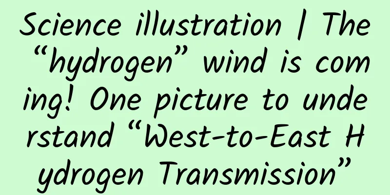
The terrain of the East Route Project of South-to-North Water Diversion is low in the south and high in the north Unable to use terrain differences to divert water by gravity Today, let us learn about East Route of South-to-North Water Diversion Project How to achieve “water flows upwards” The South-to-North Water Diversion Project, which crosses mountains and rivers, passes through cities and villages, and continuously transports the abundant water from the Yangtze River in southern China to the water-deficient north. The South-to-North Water Diversion Project is my country's largest water conservancy project. Three water diversion routes, east, middle and west, are planned from the lower, middle and upper reaches of the Yangtze River, connecting with the Yangtze River, Huaihe River, Yellow River and Haihe River, forming an overall pattern of China's water resources "four horizontal and three vertical, north-south allocation, east-west mutual assistance". The East Route Project draws water from the middle and lower reaches of the Yangtze River in Jiangsu Province. The terrain gradually rises from south to north, reaching the highest point of Dongping Lake, with a drop of more than 40 meters. The first phase of the East Route Project of the South-to-North Water Diversion Project aims to make the Yangtze River water flow upstream through a group of pump stations. After the East Line water source draws water from the main stream of the Yangtze River in Jiangsu Province, it uses the Beijing-Hangzhou Grand Canal and its parallel rivers to transport water, connects lakes in various places as regulating reservoirs, and pumps water into Dongping Lake step by step through pumping stations. The design of the pump station varies depending on the terrain and water lifting height requirements, but each pump station consists of three parts: an inlet pool, a pump room, and an outlet pool. Water enters from the inlet pool, and the pump room draws water and then sends it out through the outlet pool, thereby achieving the purpose of lifting water. The pump station works mainly by generating lift through the rotation of blades. It can pump 300,000 cubic meters of water every day, so the pump station group ensures the reliability of water diversion. The first phase of the East Route of the South-to-North Water Diversion Project is 1,467 kilometers long. There are 13 cascade pump stations, 22 hubs, 34 pump stations, and a total head of 65 meters. It has the characteristics of large scale, multiple pump types, low head, large flow, and high annual utilization hours. It is precisely because of the existence of the 13-stage East Line pump station group along the line that the East Line Project has achieved the goal of "water flows to higher places", successfully transferring water from the Yangtze River to the northern region, and playing a huge role in ensuring the security of water resources in the northern region. Source: National Joint Research Center for Yangtze River Protection and Restoration |


Recommend
What are the functions of the Gardening Mini Program? How much does it cost to develop a garden art app?
Nowadays, more and more people like to visit vario...
What is the advertising process on iQiyi?
If you have free time, you must watch TV series! ...
I spent 20,000 yuan, why is there not a single conversion?
“I know that half the money I spend on advertisin...
Carrying the weight forward: the magical function of exoskeleton equipment
A normal adult has 206 bones in his body, and our...
Don’t worry if you forget to bring your ID card! A guide to using the 12306 temporary bus certificate
As the Spring Festival approaches, many people ha...
Meizu PRO 6 Plus review: It can still be an Android flagship without Qualcomm
Before November 30, when people talked about this...
The only martyr among the heroes of "Two Bombs and One Satellite"! Today, we commemorate the 53rd anniversary of Guo Yonghuai's death!
December 5, 1968 Huairen Hall in Zhongnanhai Prem...
How much does it cost to be an agent for a photo app in Yantai?
How much does it cost to be an agent for a photo ...
Microsoft Office iOS / iPadOS version upgraded to a new design: a lot of rounded UI, light background buttons
[[440046]] On December 13, according to feedback ...
Why has QQ Space remained popular for 11 years?
QQ Space is an accessory of QQ. Without the depen...
Community Operation SOP Construction Methodology
This content will share the methodology of SOP fr...
New App Promotion Techniques: Video Promotion Makes Your App Popular Overnight
Everyone on the Internet is familiar with Chai Ji...
E-commerce is rampant in the circle of friends: This is not the way to make money from acquaintances
The debate about WeChat business is getting more ...
Misunderstood Marketing
If we go back to 2000, facing the backward econom...
French students design radiation-proof underwear to prevent smartphones from killing sperm
Mobile phones emit radio waves, and whether the u...