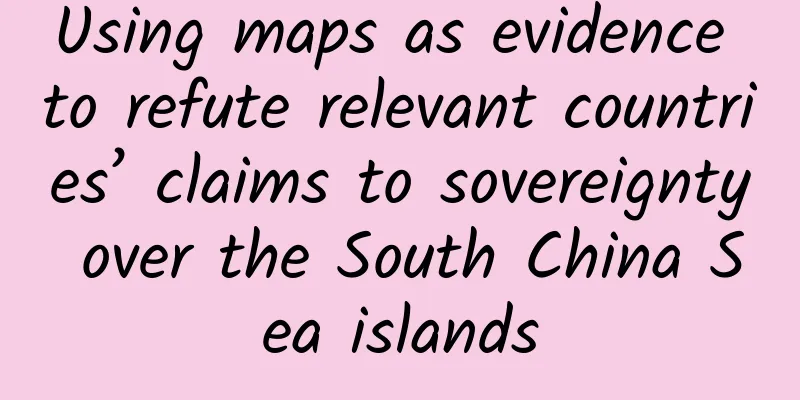
Using maps as evidence to refute relevant countries’ claims to sovereignty over the South China Sea islands
|
Reprinted with permission from the South China Sea Network (www.thesouthchinasea.org.cn) Late 18th century French map "Champa, Cochinchina, the Gulf of Tonkin, and the Coast of China and the Philippine Islands" The French map "Carte Palate Qui comprend les Costes de TSIOMPA de la COCHINCHINE le Golfe de TUNQUIN une partie des Costes de la CHINE avec une partie de l'Archipel des Isles PHILIPPINES" in the late 18th century shows that the nine small islands were not originally shown on the map, but were later scribbled in the corresponding positions with brown marks. This shows that neither the Annamites nor the French knew where the nine small islands were, and the brown marks were added by the people who used the map at the French Far East School after the French occupied the nine small islands. This shows that there is no evidence for the French government's claim in 1930 that Annam had the so-called "prior rights" to the Spratly Islands. The fact that the French added the nine small islands to the map just reflects that it was an undisputed fact that they were forcibly occupied. Map of Champa, Cochinchina, the Gulf of Tonkin, and the Coasts of China and the Philippine Islands The French added nine small island markings in brown (partial image) Guillaume Denan, France, 18th century "Coastal Map of Champa, Cochinchina, the Gulf of Tonkin, China, and the Philippine Islands" A map of Champa, Cochinchina, Tonkin Bay, China and the Philippine Islands drawn by Guillaume Dheulland (1700-1770) in France in the 18th century. The location of the Spratly Islands is still blank, indicating that France knew nothing about the Spratly Islands at that time. This map uses brown markers to manually mark the location of the nine small islands in the Spratly Islands occupied by France in 1933, which also proves that France’s claim to the nine small islands is untenable. Coastal Map of Champa, Cochinchina, the Gulf of Tonkin, China, and the Philippine Islands Nine small islands were marked by hand (partial map) The Spanish compiled and printed the "Map of the Philippine Islands" in 1744 The Map of the Philippine Islands (Mapa de las Yslas Philipinas) was drawn by Jesuit Pedro Murillo Velarde and published in Manila in 1744. The map shows three reefs near the coast of Luzon Island, Galit in the north, Panacot in the middle, and Lumbay in the south. The Philippines believes that the "Panacot" shoal comes from the transliteration of Tagalog, the native language of the Philippines, which is China's Huangyan Island, and further proposes that the indigenous people of the Philippines are the most likely people to have discovered Huangyan Island first. In fact, when the Spaniards drew this map, the British merchant ship Scarborough had not yet encountered an accident in Huangyan Island. The Filipinos and the Spanish were not aware of the existence and location of Huangyan Island, otherwise the British merchant ship would not have encountered an accident due to deviation from the route. The image of Panacot reef shown in this map is also inconsistent with the shape of Huangyan Island, so it is not enough to use this map alone to prove that Huangyan Island belongs to the Philippines, and its view cannot be established. Map of the Philippine Islands Published in France in 1753 "Map of the Eastern Ocean from the Cape of Good Hope to Japan" When the famous French royal cartographer Jean Baptiste Nicolas Denis d'Apres de Mannevillette (1707-1780) republished his book Le Neptune Oriental in 1753, he revised the Dutch chart based on the results of astronomical observations of the French Royal Academy of Sciences and added a newly drawn chart: "Cart Réduite de L'Ocean Oriental Depuis le Cap de Bonne Espérance, Jusqu'au Japon", which is a chart of the East Ocean from the Cape of Good Hope to Japan. This French version of the chart depicts three atoll-shaped shoals off the west coast of Luzon Island near the Philippine Islands, named from north to south: B. Bolinao (Bolinnao Shoal), B. Marsingola (Ma Shengyu Luo Shoal), and B. Mariveles (Marifore Shoal), but Huangyan Island is not drawn. That is to say, until the Scarborough ran aground and sank, neither the Filipinos nor the Europeans who came from the East were aware of the existence of Huangyan Island. Chart of the Oriental Ocean from the Cape of Good Hope to Japan Painted in England in 1755 Asia Part II: China, India, and Tartary; Sunda Islands, Malacca, the Philippines, and Japan In 1755, the map compiled by British cartographer Solomon Bolton, "Second part of Asia. being China, part of India and Tartary: the islands of Sonda, Molucka, Philippin and Japan", also marked three atolls near the west coast of Luzon Island. The image of the Philippine Islands was almost correct, but Huangyan Island was still not drawn. Second part of Asia. being China, part of India and Tartary: the islands of Sonda, Molucka, Philippin and Japan The French compiled the "Chinese Sea Chart" in 1766 Huangyan Island was correctly drawn on the map drawn by Europeans because the Scarborough, a merchant ship belonging to the British East India Company, ran aground on Huangyan Island in 1748. In order to commemorate the accident, Huangyan Island was named Scarborough Shoal or Scarboro (meaning a sandbar or shoal visible when the water level drops). The Chart of the China Sea was compiled by the French based on the marine information provided by ships sailing in the South China Sea between 1744 and 1765. Many routes were drawn on this chart, and a sandbar was drawn with dots and crosses to mark "Scarboro" (Huangyan Island). Three shoals were drawn on the west coast of Luzon Island in the Philippines, but they were not named. Obviously, they had nothing to do with "Scarboro" and were separated by a long distance. This also proves that Europe's initial cognition and naming of Huangyan Island had nothing to do with the so-called "Panacot" shoal, and Huangyan Island was not first discovered by the indigenous people of the Philippines. Chart of the China Sea 1778 British Chart of the China Sea, the Philippine Islands, and the Filizia and Sulu Islands A Chart of the China Sea and the Philippine Islands with the Archipelagos of Felicia and Soloo was drawn based on the hydrographic map of the Philippine Islands compiled by Jesuit Pedro Murillo de Velarde in 1734, combined with new data from British nautical surveys. The map not only annotates the names of the three shoals in English, but also reproduces the names used in the hydrographic map of the Philippine Islands: the northern shoal is Galit, the middle shoal is Panacot, and the southern shoal is Lumbay. The Scarborough Shoal (Huangyan Island) is annotated with "The Scarborough Sept. 12th 1748", which means that the Scarborough sank on September 12, 1748, the day when the British tea-carrying sailing ship hit the shoal. The simultaneous drawing of Panacot Shoal and Scarborough Shoal (Huangyan Island) in this nautical chart proves that the two have no relationship at all. A Chart of the China Sea and the Philippine Islands with the Archipelagos of Felicia and Soloo New Chart of the China Sea and Its Passages, 1794, Britain On this British-published nautical chart, "A NEW CHART OF THE CHINA SEA with ITS SEVERAL ENTRANCES", a half-moon-shaped atoll (Huangyan Island) is drawn on the west side of the three atolls off the west coast of Luzon Island, with the names "Scarborough Shoal" and "the Negroes Head". The location where the Scarborough sank is drawn on the northwest side of the shoal, with the note "Scarborough Sept. 12th 1748". There are three relatively large islands, reefs or shoals between Huangyan Island and the Philippine Islands, from north to south: "Double Headed Shoal or North Maroona Rocks above Water" (Double Headed Shoal or North Maroona Rocks above Water), "Marsingola or South Maroona" (Marsingola or South Maroona) and Lambay or Mariveles Shoal (Lumbay in the native Tagalog of the Philippines or Mariveles Shoal). "Marsingola or South Maroona" is the Panacot Reef mentioned above, and Scarbro Shoal (Huangyan Island) has nothing to do with the three offshore islands and reefs. This proves that Panacot Island is not Huangyan Island at all. A NEW CHART OF THE CHINA SEA WITH ITS SEVERAL ENTRANCES Local map 1906 American Caspar Hodson Map of the Philippine Islands In 1906, American Caspar W. Hodgson compiled a map of the Philippine Islands based on the Paris Treaty data: MAP OF THE PHILLIPINE ISLANDS. The most crucial evidence on the map is that on the left side of the map, along the 118° east longitude, a line consisting of dots and horizontal lines was drawn on the sea surface, annotated "PARIS TREATY LINE", which is the Paris Treaty Line, which is also the western boundary of the Philippines defined by the Paris Treaty. This treaty line separates Scarborough Shoal (now Huangyan Island) outside the line, which means restoring the original name of Huangyan Island given by the British in the 18th century and canceling the name given by the Spanish in the 19th century. It proves that Huangyan Island does not belong to the territory under the jurisdiction of the Philippines. MAP OF THE PHILLIPINE ISLANDS 1908 American Caspar Hodson Map of the Philippine Islands In 1908, Caspar W. Hodgson, based on the information of the Treaty of Paris, once again asked A. BRIESEMEISTER to draw and engrave a larger map of the Philippine Islands: MAP OF THE PHILLIPINE ISLANDS, which was printed and published in New York, USA. In this new version of the 1908 map of the Philippine Islands, which was published two years later, Caspar Hodgson added a caption below the title, thanking the United States Coast and Geodetic Survey, the Military Intelligence Division of the Army Department, the Hydrographic Office of the Navy Department, and the Philippine Education Bureau, Public Works Bureau, Post Office, Science Bureau, Ethnological Survey and Police Bureau. This shows that the map was compiled and drawn after official surveys and revisions by the United States and the Philippines and published publicly, and the Philippine territory and national boundaries on the map were officially recognized. On the left side of the map, a line consisting of dots and horizontal lines is drawn on the sea surface along the 118° East longitude, marked with the "PARIS TREATY LINE". This is the western boundary line of the Philippines defined by the Treaty of Paris, while Scarborough Shoal is outside the treaty line, which means that Huangyan Island does not belong to the territory under the jurisdiction of the Philippines. MAP OF THE PHILLIPINE ISLANDS Near Huangyan Island (partial map) Huangyan Island is located outside the international treaty line of 118 degrees east longitude (partial map) Printed by the Philippine Government in 1961 Map of the Republic of the Philippines MAP OF REPUBLIC OF THE PHILIPPINES, printed by the Philippine government in 1961. The information in the map comes from the Coast Geodetic Survey, the Bureau of Population Statistics, the Library of Congress, the Commission on Elections, the Bureau of Public Affairs, the Bureau of Land, the National Planning Commission, the National Library, insurance companies, banks, etc., combined with private maps, real estate agents, private archives and visual surveys. It can be said that the information is rich and comprehensive. It was compiled by DDDE JESUS and has the authority of the official map of the Philippines. On this color map, a circle of horizontal lines is drawn around the Philippine Islands, with the annotation "International Treaty Limit", which means that this line is the boundary of the Philippine country determined according to international treaties, and the western limit of this international treaty line coincides with the meridian of 118° east longitude. Outside the western limit of the international treaty line, four small maps are arranged from top to bottom in corresponding positions: Philippine topographic map, Philippine population distribution map, Philippine climate map and Philippine water conservancy and electric pump irrigation map. There is no mark on Huangyan Island on the map, which proves from another side that Huangyan Island does not belong to the Philippines. MAP OF REPUBLIC OF THE PHILIPPINES |
<<: How do we find those children who have been abducted for many years?


Recommend
Feet: Don’t tell my mouth, I can taste garlic too!
As the saying goes: If you don't eat garlic, ...
Are super males "violent demons" and super females "stupid beauties"?
Review expert: Mao Xinmei, Chief Physician of Ped...
Why can’t Zhou Hongyi forget about search?
2015 was still a high-profile year for Zhou Hongy...
What are these "little bumps" on your scalp? How can you prevent them? Here are the answers...
This article was reviewed by: Xiaobo Zhou, Doctor...
How does Tesla do marketing with zero advertising investment?
They are both beverages, so why can Yuanqi Forest...
"Space Photographer" Takes Action, Leaving More Than Just Beauty
Astronauts from home and abroad have taken many p...
Samsung is doomed? Which domestic mobile phone company can take over?
With powerful marketing methods and the hype crea...
One article will clarify the product’s pain points, itching points, and selling points!
What does marketing rely on to start? In the fiel...
Cocos Engine supports LeEco Ecosystem •Developer Conference and promotes the development of the Internet application industry
Recently, LeEco Ecosystem Developer Conference wa...
Fairy shrimps were discovered in Jiangsu, and they have existed for 200 million years! More important than whether they can be eaten is...
Expert of this article: Liu Yadan, researcher, de...
Zuo Zhijian - 15 practical lessons on financial management for beginners to help you seize more opportunities to make money
The course "Zuo Zhijian - 15 Practical Finan...
The internet-famous wolf in Kekexili was hit and killed by a car? This may be due to feeding
This Monday, many netizens posted on social media...
What are the benefits of growing vegetables in space for astronauts? Not just eating fresh food!
How to use plants to ensure the food, oxygen and ...
Deconstructing community growth: sending red envelopes, group points, and super users!
I have been engaged in community marketing for th...
Strawberries have the most pesticides? Are all large strawberries sprayed with growth enhancers? 7 questions about strawberries answered all at once!
Image from: freepik.com It’s the season for eatin...