
What will happen to the Qinghai-Tibet Plateau if global warming rises by 2°C?
|
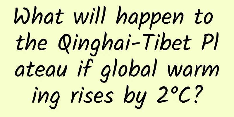
If the global temperature rises by 2°C, what will be the impact on the Qinghai-Tibet Plateau, known as the "Third Pole of the Earth" and "Asian Water Tower"? Scientists' latest research gives the answer: Under the scenario of global warming of 2°C, the climate of the Qinghai-Tibet Plateau will continue to become wetter, precipitation will increase, and the total runoff of major rivers and the per capita water consumption in the upper reaches of the Yangtze River and the Yellow River will also increase accordingly. Distribution map of per capita water resources in the upper reaches of major rivers under different warming scenarios The Qinghai-Tibet Plateau is the source of many of Asia's major rivers, and has a significant impact on the lives, economic development and social stability of billions of people in the surrounding areas. Since 1960, the Qinghai-Tibet Plateau has been warming at twice the global warming rate. Against this background of abnormal warming, the Qinghai-Tibet Plateau has become wetter overall, but with obvious regional differences, as reflected by reduced precipitation in the monsoon region and increased precipitation in the westerly region. In 2015, the Paris Climate Change Conference proposed to control the increase in global average temperature within 2°C by the end of this century. Under this temperature control target, the temperature of the "Asian Water Tower" will surge by 4°C. So, under the scenario of global warming of 2°C, how will the water supply of the "Asian Water Tower" change? How will the per capita water resources in the upper reaches of the main rivers of the "Asian Water Tower" evolve? These are still unresolved issues. Earth system models are an important tool for predicting climate change. However, there are huge differences in the predictions of future precipitation by the models that have participated in the Intergovernmental Panel on Climate Change (IPCC) assessment reports, and the credibility of model predictions in the Qinghai-Tibet Plateau is extremely low. In addition, there are deviations in the simulation of key land surface hydrological processes, including evapotranspiration and soil moisture, and most of them lack the description of mountain cryosphere hydrological processes. Therefore, based on the current Earth system model, there is great uncertainty in predicting future changes in runoff on the Qinghai-Tibet Plateau. Changes in runoff of major rivers on the Qinghai-Tibet Plateau under different warming scenarios To this end, Wang Tao, a researcher at the Qinghai-Tibet Plateau Institute of the Chinese Academy of Sciences, and his collaborators started from the core idea that the synergy between the Indian monsoon and the westerly winds is the core driving force behind the changes in the hydrosphere of the Qinghai-Tibet Plateau. They integrated multi-source observation data to constrain the future projections of wet season precipitation and runoff by the Earth system models participating in the fifth and new rounds of the International Coupled Model Intercomparison Program (CMIP5 and CMIP6), and drew a distribution map of per capita water resources in the upper reaches of major rivers including the Indus, Ganges, Yarlung Zangbo, Nujiang, Mekong, Yangtze and Yellow rivers. The results show that under the global warming scenario of 2°C, the Qinghai-Tibet Plateau will continue to become wetter, and the increase in precipitation in the monsoon region (3.9%) will be significantly higher than that in the westerly region (0.8%). The total runoff of major rivers in the wet season will increase (4.1%), with the largest increase in the upper reaches of the Ganges (10.8%) and the smallest increase in the upper reaches of the Indus River (1.2%). Glacial meltwater mainly leads to the increase in runoff in the upper reaches of the Indus River. Although the water supply of the "Asian Water Tower" has increased, it does not always increase the per capita water availability in the upper basins: the future population decline in the upper basins of the Yangtze River and the Yellow River will increase the per capita water availability in these regions, while the future population increase in the upper reaches of the Indus and Ganges will offset the positive impact of increased runoff. This study has important scientific significance for improving water resources management and promoting the realization of regional sustainable development goals to ensure water and food security. Precipitation changes in major river basins on the Qinghai-Tibet Plateau under different warming scenarios The research results were published online in the internationally renowned journal Nature Climate Change on January 11. The research was funded by the Second Comprehensive Scientific Survey and Research on the Qinghai-Tibet Plateau and the Basic Science Center of the National Natural Science Foundation of China. Article link: https://www.nature.com/articles/s41558-020-00974-8 Source: Institute of Tibetan Plateau Research, Chinese Academy of Sciences |
>>: About masks—are they really just a few layers of cloth?


Recommend
Don't rush to take a picture of a bug on your face! The unique skills of the fart beetle, the "disfigurement" of chemical weapons is too scary
Recently, there was a news report that a citizen ...
What kind of cat is this! I can't see or pet it, but I have to clean up its poop every day
I study desert cats, so every holiday I am always...
Ren Zhengfei: 90-day "temporary permission" is meaningless because we are ready
On May 21, Ren Zhengfei, founder and president of...
This is how the foundation of "quantum mechanics" was born
The word atom was invented by the ancient Greeks,...
Google has returned to China with its head down. Can it pay the price for its past willfulness?
Recently, there is news that Google has made a pr...
Xiaohongshu KOL distribution model and content marketing methodology
We provide you with a practical summary of brand ...
Will young people develop age spots if they stay up late? Young people do develop age spots, but the reason is...
Rumor: "Young people who stay up late will d...
Original content: Team building, operation and promotion of WeChat public accounts in universities
Today, I will analyze the team building, operatio...
Is the Yanbian Hotel Mini Program agency fee high? Yanbian Hotel Mini Program Agency Fees and Process
Is it easy to be a Yanbian Hotel Mini Program age...
Cloud gaming has arrived as expected, is the smart TV industry really ready?
It has been 11 years since the concept of cloud g...
A small action can determine whether your knees are healthy! Try it now →
As the saying goes, the legs are the first to age...
How to cleverly use celebrities to achieve a cold start for a product?
For those who work in operations , the word they ...
Nokia returns with a strategy of launching a large number of smartphones: at least five smartphones next year
Nokia smartphones are getting closer and closer. ...
Tik Tok advertising, the complete process of information flow promotion, targeting precise users!
For a complete Douyin advertising campaign, the i...
How to do community operation? Positioning and user analysis are equally important!
Community operation is currently a popular operat...