
Which ocean satellites has my country independently developed?
|
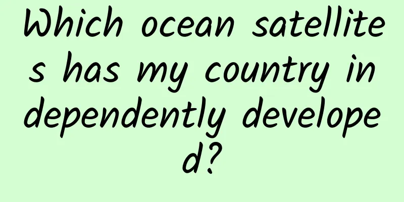
my country has always attached great importance to the monitoring and investigation of marine resources. my country's marine remote sensing technology began in the 1970s, and a long-term independent marine satellite development plan was formulated. On May 15, 2002, the first Ocean No. 1A satellite (HY-1A) was launched into space, filling the gap in my country's marine satellite field and opening a new era for the development of the "Ocean No. 1" series of satellites. Up to now, my country has launched a series of ocean color satellites (namely the "Ocean No. 1" series of satellites), a series of ocean dynamic environment satellites (including the "Ocean No. 2" series of satellites and Sino-French ocean satellites), and an ocean surveillance and monitoring satellite (namely the "Ocean No. 3" series of satellites). Part 1 Ocean Color Satellite Series The ocean color satellite series are ocean remote sensing satellites that use visible light and infrared imaging observations. They mainly include the "Ocean One" series of satellites that have been launched, namely Ocean One A Satellite (HY-1A), Ocean One B Satellite (HY-1B), Ocean One C Satellite (HY-1C), and Ocean One D Satellite (HY-1D). HY-1A was launched in 2002, equipped with a 10-band water color scanner and a 4-band imager. Its main task is to detect ocean water color environmental factors (such as chlorophyll concentration, suspended sediment content, soluble organic matter), water temperature, pollutants, shallow sea depth and underwater topography. HY-1B launched in 2007 is the successor of HY-1A, with basically the same payload and performance as HY-1A. HY-1C was successfully launched on September 7, 2018, ushering in a new era of coordinated development of China's natural resources satellites on land and sea. HY-1C is equipped with five major payloads, including an ocean color and temperature scanner, a coastal zone imager, an ultraviolet imager, an onboard calibration spectrometer, and an automatic ship identification system. Compared with HY-1A and HY-1B, the observation accuracy and range have been greatly improved. Figure caption: The Yellow River estuary photographed by the HY-1C satellite HY-1D was successfully launched on June 11, 2020, and its technical performance is basically the same as that of HY-1C. Ocean water color detection requires high conditions and is also affected by solar flares, sea foam and cloud shadows. HY-1D and HY-1C form China's first marine civil service satellite constellation, opening the curtain on China's marine satellite networking. Through the morning and afternoon networking observations of HY-1C and HY-1D, the daily observation frequency and the amount of observation data obtained can be doubled: the sea areas affected by solar flares in the morning can be avoided in the afternoon; the sea areas covered by clouds in the morning and the unobserved areas have the opportunity to be compensated in the afternoon. This move can greatly improve the effective observation capabilities of global ocean water color, coastal resources and ecological environment, and provide support for applications in meteorology, agriculture, water conservancy, transportation and other industries, marking that China has entered the forefront of the international ocean water color remote sensing field. Since the launch of HY-1A on May 15, 2002, my country has successfully built a family of Chinese ocean color observation satellites named "Ocean No. 1" in the field of ocean satellites. The "Ocean No. 1" series of satellites have shifted from experimental applications to business services, playing an important role in natural disaster monitoring, resource surveys, Arctic and Antarctic expeditions, ecological civilization construction and the construction of a strong maritime nation. Taking HY-1C as an example, this satellite has made outstanding contributions in monitoring the tuna fishing grounds of Papua New Guinea in the offshore fishery, the Enteromorpha appearing in the Yellow Sea and the East China Sea, the frozen ice and sea ice of the Hoh Xil Salt Lake, red tides, oil spills, and reclamation. Figure Note: Papua New Guinea tuna probability map produced using HY-1C, HY-2B, EOS/MODIS and other satellite data Caption: HY-1C satellite continuously monitors the sea ice in the Bohai Sea (pictured on January 9, 2019) Figure caption: HY-1C satellite data Sanya oil spill emergency remote sensing detection map (continuous remote sensing monitoring of oil spills from ships near Sanya provides auxiliary decision-making support for rapid response to offshore oil spills, emergency treatment, and marine ecological environment protection and restoration) Part 2 Ocean Dynamics and Environment Satellite Series The ocean dynamic environment satellite series includes the "Ocean No. 2" series satellites and the Sino-French ocean satellites. The "Ocean No. 2" series payloads include microwave scatterometers, radar altimeters and microwave radiometers, integrating active and passive microwave remote sensors, with high-precision orbit measurement and orbit determination capabilities and all-day, all-weather, global detection capabilities, and obtain ocean dynamic environment information including sea surface wind fields, sea surface heights, wave heights, ocean gravity fields, ocean currents, sea surface temperatures, etc. in China's coastal waters and around the world, greatly enhancing my country's ability to monitor the ocean, maintain maritime rights and conduct marine scientific research. The Sino-French Ocean Satellite (CFOSAT) was successfully launched on October 29, 2018 at the Jiuquan Satellite Launch Center in China using a Long March 2C carrier rocket. As the first satellite jointly developed by China and France, CFOSAT is the first in the world to achieve large-scale, high-precision synchronous joint observation of ocean surface wind and waves. CFOSAT obtains global sea surface wave spectrum, sea surface wind field, and Antarctic and Arctic sea ice information, promotes the understanding of sea-air interaction, predicts ocean surface wind and waves, and monitors ocean conditions. It can also play a role in atmosphere-ocean interface modeling, analysis of the role of waves at the atmosphere-ocean interface, sea ice and polar research, and climate change. CFOSAT will enhance the ocean remote sensing observation capabilities of China and France, lay the foundation for applied research cooperation and global climate change research between the two sides, and is of great significance and far-reaching impact. Since its successful launch in August 2011, HY-2A has acquired a large amount of global ocean dynamic environment remote sensing data and distributed data products to dozens of users in the fields of oceanography, meteorology, disaster prevention, disaster reduction, agriculture and scientific research across the country. It has also provided product services to Europe and other countries, realizing commercial operation. HY-2B was launched in October 2018. It is my country's second ocean dynamic environment satellite and also an ocean business satellite planned for my country's civil space infrastructure. HY-2B has added payloads such as a correction radiometer, a data collection system, and an automatic ship identification system. It has high-precision orbit measurement and orbit determination capabilities and all-weather, all-day, and global ocean detection capabilities. Figure caption: Distribution of global sea surface wind fields on March 1, 2018 as observed by microwave radiation carried by HY-2B (data source: HY-2B data released by the National Satellite Ocean Application Center. In the figure, typhoons can be seen forming in eastern Japan and the northern Pacific Ocean) HY-2C is an ocean dynamic environment satellite operating in an inclined orbit (non-sun synchronous orbit). It was launched in September 2020. Its payload includes radar altimeter, microwave scatterometer, corrected microwave radiometer, satellite Doppler orbit determination and positioning system (DORIS), dual-frequency GPS, data collection system and ship automatic identification system, etc. It can provide sea surface wind field, height, sea surface height anomaly and significant wave height data, and its on-orbit life is increased to 5 years. HY-2D was successfully launched in May 2021, and its technical performance is the same as HY-2C. HY-2B, HY-2C and HY-2D form a network of one polar orbit and two inclined orbits, forming my country's first ocean dynamic environment satellite constellation, and together constitute my country's ocean dynamic environment monitoring network. Part 3 Ocean surveillance satellite series The ocean surveillance satellite series includes the "Ocean No. 3" series of satellites, which inherit the technical foundation of the Gaofen-3 (GF-3) satellite currently in orbit, and the main payload is a multi-polarization, multi-mode synthetic aperture radar (SAR). It actively transmits microwave beams to the sea surface, and then receives backscattered echoes from the sea surface to obtain sea surface information; it improves rapid response capabilities and expands the scope of ground observation through left and right attitude maneuvers; and it uses synthetic aperture technology and pulse compression technology to achieve high-resolution (1 meter) two-dimensional images of the ocean and land surfaces. The Gaofen-3 satellite was launched on August 10, 2016. The SAR it carries has 12 imaging modes, which can detect the earth and observe the sea, achieving the effect of "one satellite for multiple purposes". The satellite has a resolution of 1 meter, which can clearly see cars on the ground, ships on the sea, and internal waves in the ocean. The spatial resolution of the Gaofen-3 ranges from 1 meter to 500 meters, and the width ranges from 10 kilometers to 650 kilometers. It can image the earth at any time, whether it is day or night, clear sky or thunderstorm. This feature is particularly suitable for disaster prevention and reduction. The "Ocean No. 3" series of satellites operate in a co-orbit distribution, and can monitor islands, coastal areas, and offshore targets around the clock and in all weather conditions, and obtain information on ocean wave fields, wind fields, storm surge floodplains, internal waves, sea ice, oil spills, etc., to meet a variety of needs such as ocean target monitoring and land resource monitoring. Figure 1: Ocean internal waves detected by GF-3 SAR At present, these ocean satellites independently developed by China have formed a scientific observation network, becoming a "weapon" for our country to explore the mysterious "blue", serving deep-sea cutting-edge research, climate forecasting and marine environment forecasting, etc., making our country among the international leaders in the field of ocean observation. Let us wait and see the stars and the sea! Note: The content of this article is excerpted from the book "Exploring the Sea - The Secrets of Ocean Observation" compiled by the State Key Laboratory of Tropical Marine Environment (South China Sea Institute of Oceanology, Chinese Academy of Sciences). Produced by: China Science Expo Author: Chu Xiaoqing, Institute of South China Sea Oceanography, Chinese Academy of Sciences The article only represents the author's views and does not represent the position of China Science Expo This article was first published in China Science Expo (kepubolan) Please indicate the source of the public account when reprinting Please indicate the source of the reprint. Reprinting without authorization is prohibited. For reprint authorization, cooperation, and submission matters, please contact [email protected] |
<<: “Happiness Trap” – Can we be happy as long as we are happy?
>>: Have you done 2 hours of outdoor activities every day?


Recommend
Why doesn’t the iPhone use USB-C but Lightning?
USB-C is becoming more and more widespread, and m...
Online earning sideline project, you will get income if you browse, you can do it all over the world
Online earning sideline project, there is income ...
Bing Dwen Dwen did a backflip in space? Can liquid be used to build a bridge? Here comes the precious footage of humans giving a lesson in space
Expert of this article: Liu Yan, Space Applicatio...
Disappointing: Apple Watch's sapphire screen is so bad
The low production volume is only one of the reas...
Some "whole wheat" breads are tricking you into gaining weight
Audit expert: Wang Guoyi Postdoctoral fellow in N...
Tractica: Global deep learning software market will reach $67.2 billion in 2025
Deep learning is a buzzword that has received muc...
Which day's class will be made up on April 2, 2022? What day of the week was the class? Attached is the latest holiday schedule for Qingming Festival!
Soon, we will be welcoming the Qingming Festival ...
The game is paused. What did you just say about Ma Mei? | Expo Daily
Your best "insider" in the scientific c...
How to plan an event well?
The essence of the activity is communication. Pre...
Amid internal and external troubles, is Samsung considering splitting up and rebuilding itself or cutting off its arms in the short term?
On November 29, Samsung announced that it was con...
Why are we attracting new users but no highly active users are left?
Some operators may feel puzzled. Why do they spen...
Microsoft announces that the "Astoria" Android app porting project has been officially abandoned
After months of speculation, Microsoft has finall...
App Annie: Five major trends in mobile apps for 2020
Recently, App Annie and BusinessofApps.com jointl...
Sony to slash staff: Will halve smartphone business staff by March next year
Another tech giant is laying off employees! Accor...
How to promote forum? How to post promotion in forums?
As a webmaster, who doesn’t want to make a name f...