
There are predictable winds and clouds in the sky! Fengyun-3G satellite was successfully launched. What are the highlights?
|
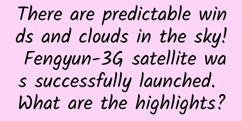
Xinhua News Agency, Beijing, April 16th , Title: Assisting high-precision monitoring of precipitation and analyzing the highlights of Fengyun-3G Xinhua News Agency reporters Huang Yao, Zhang Jiansong and Song Chen At 9:36 am on April 16, my country's first low-inclination orbit precipitation measurement satellite, Fengyun-3G, was successfully launched at the Jiuquan Satellite Launch Center on a Long March 4B carrier rocket. At 9:36 on April 16, my country successfully launched the Fengyun-3-07 satellite into space using the Long March 4B carrier rocket at the Jiuquan Satellite Launch Center. The satellite entered the planned orbit smoothly and the launch mission was a complete success. Xinhua News Agency (Photo by Wang Jiangbo) At 9:36 on April 16, my country successfully launched the Fengyun-3-07 satellite into space using the Long March 4B carrier rocket at the Jiuquan Satellite Launch Center. The satellite entered the planned orbit smoothly and the launch mission was a complete success. Xinhua News Agency (Photo by Wang Jiangbo) This is the third active precipitation measurement satellite launched internationally, following the joint launch of a dedicated precipitation measurement satellite by the United States and Japan. It is also the first "made in China" satellite to be added to the global precipitation satellite family. Since then, my country has become the only country in the world that simultaneously operates four low-Earth orbit civil meteorological satellites: morning, afternoon and inclined. The Fengyun-3G satellite has a lifespan of 6 years. It is developed by the Eighth Academy of China Aerospace Science and Technology Corporation, and the ground application system is developed, constructed and operated by the China Meteorological Administration. What are the highlights of this newly launched "precipitation satellite"? How will it forecast the weather more accurately? A CT scan of precipitation Precipitation is an important part of the water cycle. Meteorological disasters occur frequently under the background of climate change. Understanding the instantaneous structure and global distribution characteristics of precipitation systems has become an important part of disaster prevention and mitigation and understanding global climate change. Fengyun-3G is my country's 20th Fengyun meteorological satellite. "The launch of Fengyun-3G will help give full play to the overall advantages of my country's low-orbit meteorological satellite observation network and will significantly improve the early warning capabilities of global disasters such as heavy rains," said Chen Zhenlin, director of the China Meteorological Administration. Traditionally, precipitation data is mainly obtained through rain gauges, ground-based radars and other means. However, due to the limited number and uneven distribution of ground equipment, it is difficult to obtain ground precipitation information with high spatial resolution over a large area. "On the one hand, ground-based precipitation measurement radars have a large number of blind spots at sea, and typhoons at sea are very important weather systems that affect our country. Previously, we lacked accurate means to monitor typhoon precipitation; on the other hand, there is terrain obstruction. For example, in the mountainous areas of the southwest, a large amount of terrain obstruction makes ground radars also have many monitoring blind spots." Zhang Peng, deputy director of the National Satellite Meteorological Center, said that satellites can make up for these blind spots and assist in precipitation monitoring and early warning. According to Qian Bin, chief designer of FY-3G of the Eighth Academy, FY-3G carries my country's first "airborne rain gauge" - a satellite-borne Ku and Ka dual-frequency precipitation measurement radar, which combines the advantages of high radar observation resolution and wide satellite observation range. The satellite has the ability to obtain three-dimensional structural information from top to bottom, just like a "CT" scan of atmospheric precipitation, obtaining detailed three-dimensional structural information of precipitation. In addition, the Ku-band and Ka-band radars of FY-3G work synchronously, and can use the different reflectivity of precipitation particles in different altitude layers of the atmosphere to the microwave signals radiated by the two-band radar to distinguish rain and snow and make accurate estimates of precipitation. The Ku-band is conducive to detecting heavy precipitation, and the Ka-band is conducive to detecting weak precipitation. The dual-frequency detection formed by the combination of the two can accurately perceive the changes in precipitation intensity of 0.2 mm/hour in the Earth's atmosphere at an orbital altitude of 407 kilometers, like drizzle. First operation in a low-inclination orbit Unlike many low-orbit satellites that use a sun-synchronous orbit, Fengyun-3G uses a low-inclination orbit with an inclination of 50 degrees. What is the reason why the Fengyun meteorological satellite is operating in a low-inclination orbit for the first time? At 9:36 on April 16, my country successfully launched the Fengyun-3-07 satellite into space using the Long March 4B carrier rocket at the Jiuquan Satellite Launch Center. The satellite entered the planned orbit smoothly and the launch mission was a complete success. Xinhua News Agency (Photo by Wang Jiangbo) At 9:36 on April 16, my country successfully launched the Fengyun-3-07 satellite into space using the Long March 4B carrier rocket at the Jiuquan Satellite Launch Center. The satellite entered the planned orbit smoothly and the launch mission was a complete success. Xinhua News Agency (Photo by Wang Jiangbo) "The inclination of the sun-synchronous orbit is slightly greater than 90 degrees. The satellite will pass through the Earth's North and South Poles in each orbit. Its observation efficiency for the polar regions is relatively high, but its observation efficiency for mid- and low-latitude regions is relatively low. The main observation object of Fengyun-3G is precipitation, which mostly occurs in mid- and low-latitude regions." Qian Bin said that Fengyun-3G uses a low-inclination orbit, and its movement range is concentrated between 50 degrees north and south latitude, which can observe the Earth's precipitation more efficiently and accurately. However, the use of low-inclination orbits also faces the challenge of complex changes in the external thermal environment. For satellites operating in such orbits, the sun will illuminate the left side of the satellite for a period of time, but after a period of time, it will illuminate the right side of the satellite. In order to ensure that the satellite always faces the sun with the same side and stabilize the satellite's external thermal environment, aerospace science and technology workers have tailored a set of automatic U-turn working modes for Fengyun-3G. During the on-orbit operation, when the sunlight moves from one side of the orbital plane to the other side, Fengyun-3G will automatically rotate and turn back and forth, always facing the sun with the same side, ensuring that the onboard instruments are always in a comfortable temperature range. Providing high-precision observation data for disastrous precipitation Cao Xiaozhong, deputy director of the China Meteorological Administration, said that Fengyun-3G is my country's first satellite to actively measure precipitation. Through the fusion of satellite and ground radars, it can realize the global three-dimensional atmosphere, cloud and precipitation structure detection. It will be used in the monitoring and forecasting of typhoons, heavy rains and other extreme disastrous weather, and play a role in the ecological environment, energy, agriculture, health and other fields. At 9:36 on April 16, my country successfully launched the Fengyun-3-07 satellite into space using the Long March 4B carrier rocket at the Jiuquan Satellite Launch Center. The satellite entered the planned orbit smoothly and the launch mission was a complete success. Xinhua News Agency (Photo by Wang Jiangbo) At 9:36 on April 16, my country successfully launched the Fengyun-3-07 satellite into space using the Long March 4B carrier rocket at the Jiuquan Satellite Launch Center. The satellite entered the planned orbit smoothly and the launch mission was a complete success. Xinhua News Agency (Photo by Wang Jiangbo) During its life cycle, Fengyun-3G will effectively monitor the development of clouds and rain inside typhoons at sea, provide high-precision observation data for disastrous precipitation such as heavy rain and blizzards, and further improve the effectiveness of global numerical weather forecasts. "Numerical forecast models have their own difficulties in predicting precipitation, and Fengyun-3G can greatly improve the accuracy of precipitation monitoring. These observation data can help improve precipitation forecasting capabilities after entering the numerical model." Zhang Peng said, "In terms of scientific research and mechanism exploration, accumulating long-term and large amounts of observation data through satellites will help us conduct in-depth research on the occurrence and development mechanism of precipitation." In view of the climatological characteristics of precipitation in my country, FY-3G will focus on conducting research on the application of its data in the monitoring, analysis and forecasting of heavy rains in South China and the Jianghuai region, the climatological research on precipitation in the Qinghai-Tibet Plateau, and the research on the characteristic mechanism of cold cloud precipitation in the north. In the next six months, Fengyun-3G will carry out in-orbit testing in accordance with the idea of "testing, applying and providing services at the same time" to fully verify the satellite platform, payload, and satellite-ground integration indicators, and make every effort to respond to meteorological disasters such as heavy rains and typhoons during the main flood season. As of now, my country has a total of 8 Fengyun meteorological satellites in orbit, which are continuously providing data products and services to 126 countries and regions around the world. |
>>: How hard is it to find a dinosaur?


Recommend
Xiaomi's halo is fading: every phone sold loses money, and dealers are not enthusiastic
Xiaomi, which just celebrated its fifth birthday,...
Can sugar-free drinks help you lose weight? Drink like this, or you'll gain weight!
Author: Tian Dawei Reviewer: Zhang Na, Associate ...
Online education APP operation: How to motivate users to complete course learning?
In an era where mobile Internet is so popular, mo...
Drink bone soup to supplement calcium? This article tells you how effective it is
Can bone soup provide calcium? The calcium in bon...
Ideas for building a Baidu promotion account, how to build a Baidu search engine account?
Many friends don’t know where to start when they ...
What should Tik Tok do to become popular? Tips to become popular on TikTok
This article mainly introduces how to become popu...
Li Ligang - Negotiation Tour - Negotiation training expert Li Ligang's nationwide lecture tour
Li Ligang - Negotiation Tour - Negotiation traini...
Top physicists will discuss the future of quantum at the birthplace of quantum mechanics
2025 was declared the "International Year of...
Unveiled zone-free cleaning technology, Haier's smart cleaning ecosystem completes continuous upgrade
As humans delve deeper into the concept of the In...
Event planning and promotion, how to plan and execute an event?
1. Event Planning Overview There are three keys t...
Huawei Qiankun Intelligent Driving helps the city and the wild, smart and brave hardcore SUV Fangcheng Baobao 8 to be launched
On November 12, BYD and Huawei jointly launched t...
When there is only one Java programmer left in the world
[[236202]] In the year 2050, there is only one Ja...
The latest research found that "Sugar oranges can no longer be eaten"? The truth...
Rumor: "'The latest research shows that ...
Huyong.com SEO: SEO optimization practical training video tutorial
Hu Yong’s personal profile: He started studying S...
The better your product is, the less important customer satisfaction is.
The customer is God; 0 negative reviews is the gr...