
Three weather maps explain the current blizzard, the coming cold wave and the counter-trend warm Arctic
|
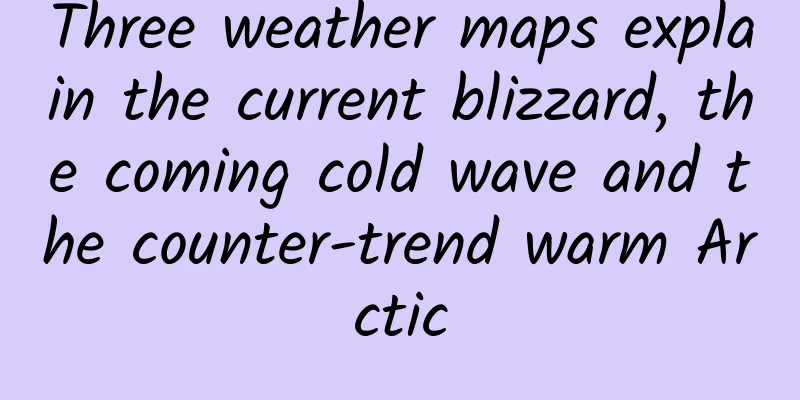
China is experiencing widespread rain and snow, and the upcoming cold wave may break the coldest record in North China. However, the Earth's atmospheric temperature is in a dynamic balance, and the extreme cold here corresponds exactly to the "warm" Arctic. 1. Large-scale rain and snow with thunder in some areas - dominated by warm air Today (13th), Beijing's primary and secondary school suspension due to blizzard warnings topped the trending search list. This is part of the nationwide rain and snow. This rain and snow process has a significant feature: the cold air is very weak, mainly dominated by warm air, which not only caused snow in the north and rain in the central part, but also strong convection in Yunnan. Only when warm and humid air currents dominate will there be large-scale precipitation weather. The precipitation forecast for the next day is as shown below. In fact, the 14th is not much different. I drew the following picture to help illustrate the current situation of the cold and warm air battlefield and the resulting weather: Under the leadership of an air current (the so-called "Southern Branch Trough") flowing around the southern side of the Qinghai-Tibet Plateau in the high-altitude westerly belt, warm and humid air currents from the Bay of Bengal, the South China Sea and the East China Sea have joined forces to move northward, causing large-scale precipitation weather. Among them, in the southernmost and warmest places such as Yunnan and Guizhou, where there are convective conditions, thunderstorms and local severe convective weather have already or will occur, in the middle of central China and other places, it is stable rainy weather, and in the coldest north, it is snowing. Weather situation map caused by the battle between cold and warm air on December 13-14 (Tao Tao Fengyun) It must be pointed out that the intersection of cold and warm is not a simple two-dimensional collision, but the warm climbing on the cold, so in the above picture, the cold and warm cross into each other's areas. The warm and humid air flow this time is very strong, which corresponds to the recent continued warm weather: 2. Cold waves come one after another - the east continues to be cold The Central Meteorological Observatory issued three warnings for heavy snow, cold wave and freezing, showing the extreme nature of this weather process. The cold wave has not yet started, and the main body of cold air is still accumulating in Western Siberia north of Xinjiang, and will move eastward and southward as a whole in the future. Not only that, as the East Asian trough continues to deepen and maintain in the future, cold air will not only be generated continuously, but also be closer to China, and the path of moving into China will be more direct. It will no longer move eastward and southward as in the initial stage, but will move directly southward, as shown in the figure below. The overall situation of cold air from December 16 to 22 (Tao Tao Fengyun) Under this situation, the central and eastern parts of my country will experience a continuous and significant cold trend for at least a week after the 16th, and the lowest temperature in some parts of North China on a certain day or for several days may break the historical extreme. 3. The Warm Arctic: Cold and Warm Are Always Swapped The earth's atmosphere is always in a dynamic balance. If cold air continues to move southward in East Asia, causing the weather to be cold, then there must be another place where warm air continues to move northward to high-latitude areas to balance it. Generally, such areas happen to be adjacent to each other, because the dominant weather system corresponds to a complete fluctuation of the high-altitude westerly belt: the north brings warmth, and the south brings cold. Schematic diagram of the future cold East Asia and warm North Pole (situation around December 19) It should be noted that the black lines in the above figure represent the airflow at high altitude (about 5,000 meters above sea level), and the red and blue arrows represent the ground and low-altitude airflow. The high-altitude airflow dominates the direction of the low-altitude airflow, but it is not completely consistent. Perhaps in the next few days we will hear news about temperatures above 0℃ in the Arctic Circle. ---End of full text--- Welcome to follow the official account: Taotao Fengyun |
<<: How many minutes should you boil eggs to make them tasty? This experiment will tell you!
>>: How to go from "white soil" to "oasis"? Let's see the "salty confession" of the earth


Recommend
Behind the 260 million yuan fine: How did Qvod become a rogue platform?
It seems impossible for Qvod to be reborn. It was...
Youzi operates two hours a day and earns more than 1,000 yuan a day.
This project was created when I was researching p...
Methods for attracting new users through event operations!
In recent years, I have seen many user operations...
12 tips to thoroughly explain Douyin operation and promotion
In this article, the author will start with the r...
How to design a suitable TV game?
I first entered the TV game industry half a year ...
How much does it cost to be an agent of Haikou Home Textile Mini Program? What is the price of being an agent of Haikou Home Textile Mini Program?
Why should you be an agent for WeChat Mini Progra...
Justill Poster Color Lab Bootcamp 2.0
Justill Poster Color Lab Training Camp 2.0 Resour...
What types of Googlebot are there?
Googlebot is generally called Google robot or Goo...
The latest cocktail party guide for ChinaJoy 2016 is here! (102 events updated at any time)
The annual ChinaJoy will be held in Shanghai from...
If you catch a cold 6 times a year, your immune system is weak? Wrong! Here are 4 things you should do →
Many parents are always worried about why their c...
How a good rice variety is cultivated
In April 2022, General Secretary Xi Jinping visit...
The monthly download volume of Bullet SMS is less than 6,000. Will Alipay be its life-saving straw?
Bullet Messenger was forced to take a roller coas...
A guide to visiting the Forbidden City during the National Day holiday, helping you understand the Forbidden City!
This article was first published by Hunzhi (WeCha...
Share a very good news client (based on Baidu data)
Source code introduction: Based on Baidu data, a ...