
What is happening to the Qinghai-Tibet Plateau under the influence of global warming?
|
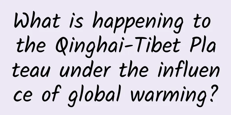
The Qinghai-Tibet Plateau is known as the "Roof of the World", "the Third Pole of the Earth" and "Water Tower of Asia". It is an important ecological security guarantee, strategic resource reserve base, ecologically fragile area in my country, and one of the most sensitive areas to global climate change. What changes have taken place in the Qinghai-Tibet Plateau under the background of global warming? What impacts have they had on my country's ecological security and weather and climate? Why do changes in the Qinghai-Tibet Plateau concern each of us? Today, nine questions and nine answers will answer your questions! 01 Why is the Qinghai-Tibet Plateau so important? The Qinghai-Tibet Plateau is the world's largest and highest plateau. Water exists here in the form of glaciers, permafrost, and lakes. This water is transported to various places on the Qinghai-Tibet Plateau through rivers, and even flows out of the Qinghai-Tibet Plateau, forming many large rivers in Asia. The Yangtze River, Yellow River, Lancang River, Yarlung Zangbo River, as well as the Amu Darya River and Syr Darya River, which have a profound impact on Central Asia, all originate in this region. These rivers provide abundant water resources for East Asia, Southeast Asia, South Asia, and even Central Asia. Therefore, from the perspective of water resources, the Qinghai-Tibet Plateau is a very important existence. On the other hand, the thermal and dynamic effects of the Qinghai-Tibet Plateau have an important impact on the weather and climate in East Asia and even the world. In addition, the Qinghai-Tibet Plateau is a natural habitat for rare wild animals and a gene bank for plateau species. It is an important area for the protection of global biodiversity and high-altitude biodiversity. It can be said that the Qinghai-Tibet Plateau is an important part of my country's "two screens and three belts" ecological security pattern, and it is also an important ecological security barrier in Asia and even the Northern Hemisphere. 02 Why is the Qinghai-Tibet Plateau called the "Water Tower of Asia"? A water tower is a device used to gather and maintain sufficient water sources and regulate stable water pressure and water volume. In mountainous areas, due to condensation and gravity, water from various sources is gathered and then continuously distributed. The Qinghai-Tibet Plateau is the highest and coldest region on Earth, and it functions as a natural water tower. The reason why the Qinghai-Tibet Plateau has become the "Asian Water Tower" is that its glaciers are endless and its ice towers are everywhere. Glaciers, permafrost, snow, lakes, rivers, etc. are all important components of the "Asian Water Tower". The complex "atmosphere-land-ocean" interaction of the Qinghai-Tibet Plateau maintains an active water cycle system on the Qinghai-Tibet Plateau. Driven by thermal and topographical dynamics, the Qinghai-Tibet Plateau is like a non-stop pump, constantly drawing water vapor from the Indian Ocean and the Western Pacific Ocean, transporting it to the Qinghai-Tibet Plateau and then entering the plateau water cycle in the form of snowfall and rainfall, replenishing the glaciers, seracs and lakes at the source of the plateau rivers. The Qinghai-Tibet Plateau is the region with the most extensive distribution of glaciers on Earth, except for the North and South Poles. It is also one of the three major snow distribution centers in my country. It also has the largest and most extensive permafrost area in the world's mid- and low-latitude regions. In addition, lakes are also scattered on the plateau. Under the towering terrain, the abundant water resources of the Qinghai-Tibet Plateau gave birth to many of Asia's major rivers. The unique topography, abundant freshwater resources and the important water resource significance of its source rivers together make the Qinghai-Tibet Plateau a veritable "Asian Water Tower". 03 Does the Qinghai-Tibet Plateau affect the global weather and climate? Yes! The thermal and dynamic effects of the Qinghai-Tibet Plateau have a significant impact on the weather and climate in East Asia and even the world. The formation of my country's summer monsoon is due to the wind blowing from the ocean with higher pressure to the land with lower pressure. The heat source of the plateau will cause the air on the ground to expand due to the heat, forming a low-pressure area on the surface of the plateau, like a giant "air pump", attracting the surrounding air to blow toward the plateau, thus creating the strong East Asian and South Asian summer monsoon. As a heat source for atmospheric uplift, the thermal effect of the Qinghai-Tibet Plateau plays an important role in maintaining the summer monsoon circulation and planetary-scale circulation. Schematic diagram of the heat source function of the Qinghai-Tibet Plateau. Xu Xiangde et al. (2019) At the same time, the mechanical blocking and friction of the Qinghai-Tibet Plateau's terrain will cause changes in atmospheric dynamics, just like the power generation device of a car engine, which is manifested as the climbing and circling of airflow when passing through the plateau. The intensification of precipitation in South China in spring is the result of the influence of atmospheric dynamics on the plateau. In addition, it can guide the tropical monsoon to turn, affecting the formation of plateau rainy seasons in India, Myanmar and other places. If there were no Qinghai-Tibet Plateau, the middle and lower reaches of the Yangtze River in my country might be a subtropical desert, my country's Xinjiang region would be directly affected by the warm and humid air currents from the Indian Ocean and have abundant precipitation, there would be no desert in the northwest region, the Loess Plateau would not be formed, and the climate in other parts of the world would undergo tremendous changes. 04 Is the Qinghai-Tibet Plateau getting warmer and wetter? Yes. Studies have shown that over the past 50 years, the Qinghai-Tibet Plateau has become significantly warmer and wetter, with the annual average temperature increasing at more than twice the global rate during the same period. Extreme high temperatures and extreme precipitation events frequently occur on the Qinghai-Tibet Plateau, while glaciers retreat, permafrost melts, and the instability of the "water tower" function increases. Meteorological disasters and their derivative disasters increase, which have a significant impact on infrastructure and the production and life of local and downstream residents. The Qinghai-Tibet Plateau, which used to be "cold at high altitudes", is now becoming one of the most typical regions affected by climate warming. According to forecasts, the Qinghai-Tibet Plateau will continue to warm in the future, and the combined risk of climate and ecological environmental disasters will increase. 05 What happened to the glaciers on the Qinghai-Tibet Plateau after warming and humidification? Against the backdrop of global warming, glaciers on the Qinghai-Tibet Plateau are retreating rapidly. Over the past 50 years, the area of glaciers on the Qinghai-Tibet Plateau and its adjacent regions has shrunk by 15%, and the area of permafrost on the plateau has decreased by 16%. The trend of retreat of small glaciers is even stronger, and some forecasts say that some small glaciers may disappear in the next 50 to 60 years. Glaciers in different regions of the Qinghai-Tibet Plateau are experiencing different degrees of melting and retreat. For example, in the southeastern or southern part of the Qinghai-Tibet Plateau, the retreat is very strong; the retreat in the central part is weaker; and in the northwest, the glaciers are still stable, and some glaciers are even moving forward. The difference in the spatial distribution of precipitation changes is one of the key factors causing the differences in the degree of glacier retreat in different regions of the Qinghai-Tibet Plateau. Landscape of ice tower forest. Photo taken in Lausanne 06 Are the lakes on the Qinghai-Tibet Plateau getting bigger? Indeed, as the glaciers retreat, the lakes on the Qinghai-Tibet Plateau are also slowly "expanding". In the past, the lakes shrank greatly, but now they are "expanding" and even flooding the grasslands... The lakes on the Qinghai-Tibet Plateau account for about 52% of the country's lake area. In the past 50 years, the number of lakes larger than 1 square kilometer on the Qinghai-Tibet Plateau has increased from 1,081 to 1,236, and the lake area has increased from 40,000 square kilometers to 47,400 square kilometers; the annual runoff of the upper reaches of the Yarlung Zangbo River and the Indus River has shown an increasing trend, and the runoff of dozens of tributaries of the Amu Darya River, Syr Darya River and Tarim River in Central Asia has increased more significantly. Yarlung Zangbo River. Photo by Luosang In the changes of lakes in the Qinghai-Tibet Plateau, the lakes in the central and northern parts have expanded more strongly. The expansion of lakes in the Qinghai-Tibet Plateau also has a certain impact on the overall climate change. From 2000 to 2019, the transparency of 152 lakes larger than 50 square kilometers on the Qinghai-Tibet Plateau showed an overall upward trend, becoming clearer and clearer. In the short term, the expansion of lake area has both advantages and disadvantages; in the long run, it may not be a good thing for the plateau ecology. 07 Is a warmer and wetter Qinghai-Tibet Plateau good for life? In the short term, the overall warming and humidification of the plateau has led to an increase in vegetation, moist air, and an overall improvement in the ecosystem. The team members of the second scientific expedition to the Qinghai-Tibet Plateau found that there was a significant increase in greenery around rivers and wetlands in the Ali region, and that wild animals such as Tibetan antelopes, Tibetan wild donkeys, and Tibetan gazelles could be seen everywhere on the roads and around lakes. Although, under the trend of warming and humidification, water resources will increase in the short term, making the ecology of the Qinghai-Tibet Plateau better, it is predicted that the supply of river runoff by glaciers will reach its maximum in the middle of this century and then begin to decrease! In the long run, the potential risk of water shortage in the future is increasing. Corresponding disaster risks will also follow, such as glacial lake outbursts, floods, mudslides, etc. In addition, snow is essential for many organisms to survive the winter, and the reduction of snow on the Qinghai-Tibet Plateau caused by global warming will lead to a large-scale shift in species distribution and may have a profound impact on biodiversity patterns. Therefore, in the future of global warming, these vulnerable or endangered species groups may face greater crises and trigger chain reactions in the global ecosystem. 08 Why does the warming and humidification of the Qinghai-Tibet Plateau affect everyone? Against the backdrop of global warming, the heat source of the Qinghai-Tibet Plateau will intensify in summer. In addition, the ecological environment of the plateau itself is extremely fragile. The enhanced effect of the plateau's heat source will bring about a series of irreversible and far-reaching impacts on the world! The Qinghai-Tibet Plateau is the source of many of Asia's major rivers. Under the background of global warming, the reduction of glaciers on the Qinghai-Tibet Plateau is accompanied by the melting of ice and snow, which will affect the flow of downstream rivers such as the Yangtze River and the Ganges, further threatening the water supply system, food safety and energy production of downstream cities, and affecting the global industrial chain. In addition, the melting of plateau glaciers and permafrost will release organic carbon sealed in ancient times in the form of carbon dioxide and methane, further exacerbating global warming. 09 What should we do to protect the Qinghai-Tibet Plateau? General Secretary Xi Jinping proposed that for the Qinghai-Tibet Plateau, we must adhere to the principle of giving priority to protection, adhere to the integrated protection and management of mountains, rivers, forests, farmlands, lakes, grasslands, and sand and ice, strengthen the protection and restoration of the ecological environment in important river basins, coordinate the rational development, utilization, and protection of water resources, and protect the living creatures, plants, rivers, and mountains here. The state has invested 30 billion yuan to build a concentrated and contiguous afforestation project in the basins of the "two rivers and four rivers" in Tibet, and has implemented the most stringent ecological protection policies to protect the diversity of plateau organisms. On the other hand, the impact of climate change on the Qinghai-Tibet Plateau has also received increasing attention from relevant departments. At the plenary sessions of the "two sessions" in recent years, many representatives and members have paid attention to the problem of warming and humidification on the Qinghai-Tibet Plateau. We should also realize that, at present, our comprehensive observation capabilities for multiple spheres of the Qinghai-Tibet Plateau are still insufficient, research on the mechanisms of climate change is insufficient, and the scientific and technological level of disaster risk assessment still needs to be improved. Researchers from the Chinese Academy of Meteorological Sciences are conducting a scientific investigation at the East Rongbuk Glacier on Mount Everest. In the future, we should further strengthen the construction of a comprehensive three-dimensional observation network for ecological and climate change on the Qinghai-Tibet Plateau, improve data acquisition and early warning capabilities for disaster risks; deepen research and scientific assessment of climate change mechanisms in sensitive areas of the Qinghai-Tibet Plateau; strengthen the rational use of climate resources, ecological restoration, and environmental protection, for example, rationally develop and utilize cloud water resources in the sky, scientifically develop and utilize western climate resources, strengthen plateau agricultural climate adaptability zoning, wetland protection, and desertification control, to achieve ecological environmental improvement, etc. Produced by China Meteorological News Agency Author: Wang Meili and Cui Guohui Image source: Xinhuanet, CCTV News, China Meteorological News, etc. Editor: Wang Meili Review: Duan Haoshu |
<<: How are typhoons named? Is it feudal superstition?
>>: Can a severed limb that has run away from home be found again?


Recommend
WeChat has been significantly updated with three new features. Netizens: What’s the difference between this and QQ?
WeChat upgraded again just before New Year's ...
How to evaluate Zhihu information flow advertising! (Attached with delivery data and materials)
As a practitioner in Internet advertising , some ...
How to prevent heat stroke in extremely high temperatures?
Summer high temperature Not only is it easy to ca...
The most outrageous way to die: GG after just a few looks?
Has everyone watched the popular TV series "...
How to make a good online event promotion plan?
In marketing psychology, herd mentality, greed fo...
It is not recommended to eat this part of the chicken! Many people don't know and still eat it...
Chicken has high nutritional value and is cheap, ...
The third session of the Aiti Tribe Technical Clinic
【51CTO.com original article】 [51CTO original arti...
How does a frog's slippery tongue catch a fly?
When it comes to frog hunting, the following scen...
Activity Operation: How to design activity prizes that stimulate user desire?
All methods of gaining traffic are designed as ba...
Break the circle on Bilibili! 5 key strategies for brand rejuvenation
Starting from animation and then blossoming into ...
How to use YouTube to attract traffic? Practical YouTube traffic generation tips
Written at the beginning: I believe everyone has ...
Marketing Promotion丨3 suggestions for brands to build their own content and influencer ecosystem
2020 is the first year for brands to focus on sho...
If a tooth is lost, can it grow back with medicine? What kind of "tooth growth" magic is this? !
Author: Huang Yanhong, Huang Xianghong, Duan Yuec...
Using Internet thinking to see LeTV TV's breakthrough in 4K
Nowadays, "Internet thinking" has becom...
VR and the Internet of Things will drive future growth of smartphones
On February 26, 2016, research firm Kantar Worldp...