
Satellite cloud images help you understand the weather: "Northeast Cold Vortex" is in the shape of a vortex! Does "arc-shaped cloud line" mean severe convective weather?
|
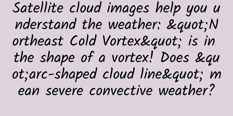
Northeast Cold Vortex The Northeast Cold Vortex is a deep cold weather system generated in the Northeast. On the 500 hPa weather map, at least one closed contour line can be analyzed, and there is a cold center or an obvious cold trough. Don't understand? It doesn't matter. It's also good if you can remember what weather effects the cold vortex will bring. Since the air in the cold vortex is in an unstable state with cold on top and warm on the bottom, it often produces unstable weather such as (thunder) showers, thunderstorms, gales or hail. Sometimes, a strongly developed cold vortex can also cause heavy rain over a large area. The vortex-shaped cloud system in the picture is a cold vortex. What should we do when we see the northeast cold vortex? The Northeast Cold Vortex is a deep weather system that moves slowly and generally lasts for 3 to 5 days, or up to 10 days, bringing several days of cold and rainy weather, or several days of showers. Remember to bring an umbrella and add or remove clothes appropriately! Since the cold vortex rotates counterclockwise around the center, it will be affected by the clouds around the cold vortex, resulting in a weather phenomenon of sometimes sunny and sometimes cloudy in a certain place under the influence of the cold vortex. Arc Cloud When a thunderstorm develops to a mature stage, heavy rainfall accompanied by strong downward airflow (or downburst) forms a cold medium and high pressure on the ground. The cold air flow that sinks to the ground will flow outward in all directions and form an arc-shaped outflow boundary. The outflow airflow interacts with the surrounding airflow to produce an arc-shaped convective cloud line composed of cumulus clouds and cumulus congestus clouds. On satellite cloud images, the arc cloud line appears as a very narrow cloud line that bulges outward (indicated by the arrow in the picture). It depicts the leading edge of the outflow boundary of cold air generated by thunderstorms, which is also called the gust front. What should I do if I see an arc-shaped cloud line? If you find an arc-shaped cloud line, it indicates that severe convective weather may occur nearby. Try to reduce outdoor activities and be careful when traveling! Karman vortex train The Karman vortex train is an important phenomenon in fluid mechanics. It refers to the phenomenon that when a fluid flows horizontally through a cylinder, vortices are alternately generated on both sides of the back of the cylinder, and a vortex wake is formed after separation. It is also called the "Karman vortex street". In fact, we often encounter Karman vortex trains in nature, such as when water flows over bridge piers, or when wind blows over tall towers, chimneys, and power lines. When the atmosphere (fluid) passes through an island, the "Karman vortex" phenomenon appears as indicated by the arrow in the figure. What should I do if I see a Karman vortex train? In meteorology, "Kármán vortex trains" are mostly formed when the wind-blown clouds are disturbed by the interference of mountains and islands. If they are affected by buildings, there is a risk of resonance caused by the Karman vortex street in strong winds. |
<<: The employees are all elites, why did the boss Liu Bei run away?
>>: How difficult is it to open a rusty mouth? Talk about "social phobia"


Recommend
Shenzhou's naked attack on Uber: poor marketing without regard for appearances
Sometimes the difference between good marketing a...
Stop eating it while it's hot! It may harm you...
A study led by the International Agency for Resea...
What are the benefits of eating Cordyceps sinensis for women?
When we see Cordyceps sinensis as a bug, we proba...
Promotional tactics for selling goods through live streaming!
Recently, Wang Leehom's live streaming lectur...
Ten thousand words long article: Detailed explanation of the 10 major formulas for trading communities
Community operation is an important means to main...
Chen Dezhong-21-day mindfulness training camp
Course Catalog ├──Day01 | ├──Day1 Course Concept:...
After climbing the mountain, I had a high fever and a rash all over my body! We have treated many cases recently, so be careful of it when you go out!
Recently, the First Affiliated Hospital of Zhejia...
The most comprehensive case analysis of event planning and operation strategies
Today I’d like to talk to you about how to run a ...
《C4D e-commerce poster season 1》——common elements
"C4D E-commerce Poster Season 1" - Intro...
Tesla: In 2023, Tesla will produce 1,845,985 new cars and its cumulative revenue will reach US$96.77 billion
According to media reports, Tesla's previousl...
Poland: Married men are three times more likely to be obese than unmarried men, study shows
According to The Guardian, a study from Poland fou...
5 marketing strategies for online and offline brands
Different types of brands engage in different for...
Want your new app to be popular before it goes online? This is how you can warm up the market!
In the film and television industry, we often hea...
APP operation strategy: some tips for developers to retain users
According to Master Chan's analysis of the &q...