
The first set of images of Fengyun-3G was released! What does the three-dimensional structure of precipitation look like when photographed by satellite?
|
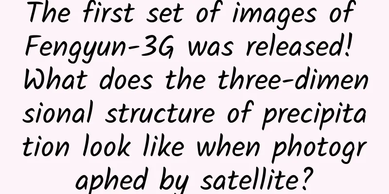
On the 15th, the first set of images of my country's first low-inclination orbit precipitation measurement satellite, Fengyun-3G (precipitation satellite), was officially released. The monitoring images of the six major payloads equipped on the Fengyun-3G released this time show the three-dimensional structure of precipitation at different levels, which is conducive to better monitoring and forecasting of disastrous precipitation systems. On May 7, a severe convective weather system appeared in South China, and the Central Meteorological Observatory issued a blue warning for heavy rain and severe convective weather. The Fengyun-3G satellite clearly captured the three-dimensional structure of this rainfall cloud system. The figure shows the three-dimensional structure of the precipitation system from 3.75 km to 6 km from the surface. Image source: National Satellite Meteorological Center The six major payloads of Fengyun-3G include four operational payloads such as precipitation measurement radar, microwave imager (precipitation type), medium resolution spectral imager (precipitation type), and global navigation satellite occultation detector, and two experimental payloads such as shortwave infrared polarization multi-angle imager and high-precision calibrator. Experts introduced that the precipitation measurement radar is the main payload on the Fengyun-3G satellite and the first satellite-borne precipitation measurement radar in China. It is mainly used for precipitation monitoring of disastrous weather systems. It uses the Ku+Ka dual band and can clearly observe the internal three-dimensional structure of precipitation systems such as typhoons, heavy rains, and blizzards. The microwave imager (precipitation type) is an upgraded version of the FY-3 batch 02 microwave imager. It realizes the integrated design of the atmospheric window area and the detection channel for the first time, with 26 detection channels, which effectively enhances the satellite's detection capabilities for precipitation and atmospheric temperature and humidity profiles. It mainly uses microwave channels set in the atmospheric window area and near the oxygen and water vapor absorption lines to capture hydrometeor data in precipitation clouds for collaborative inversion of precipitation parameters. A mosaic of brightness temperatures in the global mid- and low-latitude regions detected by the Microwave Imager (precipitation type) from May 2 to May 5. Image source: National Satellite Meteorological Center The “unique skills” of Fengyun-3G Fengyun-3G was successfully launched at Jiuquan Satellite Launch Center on April 16. This is the third active precipitation measurement satellite launched internationally after the United States and Japan jointly launched a dedicated precipitation measurement satellite. Its successful launch marks that China has become the only country in the world that simultaneously operates four low-Earth orbit meteorological satellites: dawn and dusk, morning, afternoon and tilt. At 9:36 am on April 16, my country successfully launched the Fengyun-3-07 satellite using the Long March 4B carrier rocket at the Jiuquan Satellite Launch Center. The satellite successfully entered the predetermined orbit and the launch mission was a complete success. Image source: Xinhua News Agency (Photo by Wang Jiangbo) 01 A CT scan of precipitation Traditionally, precipitation data is obtained mainly through rain gauges, ground-based radars and other means. However, due to the limited number and uneven distribution of ground equipment, it is difficult to obtain ground precipitation information with high spatial resolution over a large area. Fengyun-3G is equipped with my country's first "airborne rain gauge" - a satellite-borne Ku and Ka dual-frequency precipitation measurement radar, which combines the advantages of high radar observation resolution and wide satellite observation range. It can transmit radio electromagnetic wave signals to the atmosphere, receive reflection signals from precipitation particles at different altitudes in the atmosphere, obtain precipitation structure information at different altitudes in the vertical direction, and realize the detection of precipitation in the vertical direction. At the same time, the satellite can also use the radar's cross-track scanning capability to detect precipitation in the horizontal direction, thereby having the ability to obtain three-dimensional structural information from top to bottom, just like a "CT" scan of atmospheric precipitation. 02 "Accurate diagnosis" of typhoons and rainstorms Fengyun-3G, also called "precipitation star" by the meteorological department, is my country's 20th Fengyun meteorological satellite. It is my country's first satellite to actively measure precipitation. Through the fusion of satellite and ground radar, it can realize the detection of global three-dimensional atmosphere, cloud and precipitation structure. It will be used in typhoon, rainstorm and other extreme weather disasters monitoring and forecasting and climate research, and significantly improve the early warning capabilities of global rainstorm and other disasters. At the same time, it plays a role in the fields of ecological environment, energy, agriculture, health, etc. 03 Dance "Space Ballet" Fengyun-3G is operating in a low-orbit, low-inclination, non-sun-synchronous orbit. The sun will appear regularly on the left and right sides of the orbital plane. The constant changes in lighting conditions make the satellite's external thermal environment complex. To ensure the stability of the external thermal environment and the single-machine working environment, the satellite needs to keep the same side facing the sun at all times. To this end, the attitude and orbit control system has designed an autonomous yaw attitude maneuver mode. When the sunlight moves from one side of the orbital plane to the other, the satellite will automatically complete a 180-degree turn and perform a "space ballet" in a flexible manner. In addition, the orbit of Fengyun-3G is about 407 kilometers above the ground, and the atmospheric density is relatively high. In years with high solar activity, the satellite's orbital altitude can decay by more than 600 meters in one day. According to mission requirements, the satellite's orbital altitude must be controlled within a deviation of 100 meters. The research and development team has gathered collective wisdom to achieve the coordinated autonomous control of satellite orbital altitude maintenance, eccentricity and orbital phase, so that the satellite can always pass over the same latitude area at a fixed altitude to ensure its business application efficiency. Comprehensive sources: National Satellite Meteorological Center, Science and Technology Daily, China Meteorological News Agency, CCTV-1, etc. |
>>: “Guide to Eating Out Safely” Series: Will your stomach agree to eating barbecue?


Recommend
Feng Xueying's baby massage class
Feng Xueying's baby massage course resources ...
Are “free-range eggs” and “selenium-enriched eggs” really more nutritious than ordinary eggs? The truth is…
Everyone knows that eggs are rich in nutritional ...
What is quantum artificial intelligence? (Part 1)
Produced by: Science Popularization China Author:...
These bad living habits are harming our eyes!
"Looking at the phone while walking", &...
A complete guide to the entry standards and qualification requirements for Douyin stores! Open sales channels quickly!
Chapter 1: Notice for Settlement Article 1 Entry ...
Combined with "Growth Hacker", let's talk about 18 cases of user growth
It took me three days to finish reading " Gr...
Practical traffic diversion skills for Douyin (Part 1)
In order to help you learn the course better, tod...
2021 Weibo, Tik Tok, and Xiaohongshu KOC Marketing Strategies
What are KOC and KOL respectively? What is their ...
WeChat responds to the "killed" process of upgrading to iOS 13.2: urgent repair is underway
Recently, a small number of netizens found that t...
Talking Sheep: Have you ever heard of a lawn mower that doesn't need to be charged?
I am Dong Dong Meow Talking animals are so fun! T...
How SEO Got My App 150,000 Downloads
After reading this article, I have a question: th...
TikTok ads account opening, TikTok ads advertising
As we all know, the entire TikTok platform is now...
What is the real Ordos like?
Ordos In most people's impression It is a nor...
Is life in space full of dangers? What changes do astronauts experience in their bodies while in space?
The human body is an extremely complex and sophis...