
Three typhoons "dance together", and typhoon red warnings continue to be issued!
|
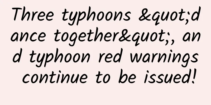
Typhoon Saura, the ninth typhoon this year At around 3:30 am today (September 2) Landing on the southern coast of Zhuhai City, Guangdong Province But the typhoon's landing does not mean the end of its impact Typhoon "Sura" will still hit South China Continuous strong winds and rains In addition, it is expected that this year's 11th typhoon "Hai Kui" It will also affect our country September 2, 6:00 The Central Meteorological Observatory continues to issue typhoon red warning According to the monitoring data of the Central Meteorological Observatory, this year's No. 9 typhoon "Sura" has weakened from a super typhoon to a strong typhoon in the early morning of this morning (September 2), and landed on the southern coast of Zhuhai City, Guangdong Province around 3:30 am. When landing, the maximum wind force near the center was 14 (45 meters/second), and the lowest central pressure was 950 hPa. After landing, it moved into the southern coastal waters of Zhuhai City, Guangdong Province again. This morning, it weakened from a strong typhoon to a typhoon. At 5 o'clock in the morning, its center was located in the southern coastal waters of Zhuhai City, Guangdong Province, that is, 21.8 degrees north latitude and 113.1 degrees east longitude. The maximum wind force near the center was 14 (42 meters/second), and the lowest central pressure was 955 hPa. It is expected that "Sura" will move westward and southward at a speed of 10 to 15 kilometers per hour, gradually weakening in intensity and approaching the sea east of Leizhou Peninsula. In addition, the center of this year's No. 11 typhoon "HAIKUI" was located at 5:00 today (September 2) on the northwest Pacific Ocean about 590 kilometers east of Eluanbi, Taiwan Province, that is, 21.9 degrees north latitude and 126.6 degrees east longitude. The maximum wind speed near the center was level 13 (40 meters/second), the lowest central pressure was 960 hPa, the radius of the level 7 wind circle was 220 to 250 kilometers, the radius of the level 10 wind circle was 100 to 120 kilometers, and the radius of the level 12 wind circle was 50 kilometers. It is expected that "Haikui" will move westward at a speed of 15 to 20 kilometers per hour, gradually increasing in intensity, and may reach the strongest typhoon level or super typhoon level (50 to 55 meters per second, 15 to 16 levels). It will land on the southeastern coast of Taiwan Island around the evening of the 3rd, then cross Taiwan Island and gradually approach the coast from southern Fujian to eastern Guangdong. In addition, at 2 a.m. on September 1, Typhoon No. 12 "Hongyan" was located about 2,680 kilometers east-southeast of Kyushu Island, Japan, with a maximum wind speed of 11 in the center, which is a strong tropical storm level. The picture shows the satellite cloud picture at 14:30 on August 31, with three stations dancing together over the northwest Pacific Ocean. Image source: National Satellite Meteorological Center This year's 9th typhoon "Surak", 11th typhoon "Haikui" and 12th typhoon "Hongyan" were formed one after another, and entangled and interacted with each other in the northwest Pacific and South China Sea regions, bringing wind and rain with great force. Strong wind forecast: from 08:00 on September 2 to 08:00 on September 3, affected by "Sura", there will be strong winds of 7 to 9, gusts of 10 to 11 in the northwest of the South China Sea, the eastern Beibu Gulf, the Qiongzhou Strait and the coast of Guangdong, the southern coast of Guangxi, the Pearl River Estuary, Hong Kong and Macao. The wind force in the nearby seas or areas where the center of "Sura" passes will be 12 to 13, gusts of 14 to 15. Affected by "Haikui", there will be strong winds of 6 to 7, gusts of 8 in the Taiwan Strait, the southern coast of Zhejiang, the coast of Fujian, the eastern coast of Guangdong, and the coast of Taiwan Island. The wind force in some sea areas east of Taiwan can reach 8 to 10, gusts of 11 to 12, and the wind force in the nearby seas where the center of "Haikui" passes can reach 12 to 13, gusts of 14. Precipitation forecast: From 08:00 on September 2 to 08:00 on September 3, affected by "Sura", parts of southwestern Guangdong, southeastern Guangxi, Hong Kong, Macao and eastern Taiwan Island will have heavy to torrential rain. Among them, parts of southwestern Guangdong will have torrential rain (100 to 180 mm). How to avoid danger when a typhoon comes How are typhoons formed? How to read the early warning signals? What disasters might it bring? Let's learn together ↓↓↓ When a typhoon comes, what should you do to prevent it at home? Comprehensive sources: China Meteorological Administration, Ministry of Emergency Management, Science and Technology Daily, China Weather Network, etc. |
<<: How do huge surface ships evade sensitive radar?
>>: The revelation of von Karman’s growth: Why did he become a once-in-a-century scientific genius?


Recommend
Which is hotter, 100℃ water or 100℃ oil?
Temperature is actually a load in mechanics. We c...
Android 13 new features and adaptation development guide
Part 01 Feature Updates 1.1 Application icons sup...
Don’t be fooled by its cute and sloppy appearance, it is actually the domineering “Elvis”!
The Shanghai Zoo recently completed the artificia...
Who is still selling mobile phones in China in 2020?
[[278575]] It’s so difficult to sell mobile phone...
Heavy rain hit Mianning, Sichuan at night and killed a family of five. 2020 is truly an extraordinary year!
On the evening of June 26, heavy rain and torrent...
Five ways to promote and attract new customers on APP
Now when you open the app store , whether it is f...
1 formula and 3 suggestions for selling products on Douyin!
Li Hao, CEO of Mars Culture, once judged that liv...
From dinosaurs to birds, why did evolution slow down?
There are some important node events in the histo...
What did Baidu do with its 7 billion research funds?
[[128328]] It is said that this is Baidu's in...
Peachtree's Practical Skills for Opening a Store Without a Source, Earn 5,000+ Per Month as a Part-time Job
Course content: 1. Xianyu practical skills: how t...
Learn from dolphins! Learn the secrets of sound waves and become more comfortable underwater~
Author: Li Chuanfu In the depths of the ocean, do...
What are the specific circumstances under which the US allowed the Pentagon to postpone the implementation of the Huawei ban?
What are the specific circumstances under which t...
This is the most comprehensive guide to all modules of product promotion and operation that I have ever seen!
When it comes to operations , everyone's firs...
There are many pitfalls on the road to treating hair loss. Why is it so difficult to grow hair?
Author: Zhang Jianzhong, Chief Physician, Peking ...