
A cartographic miracle! A 430-year-old hand-drawn giant world map opens your journey through time
|
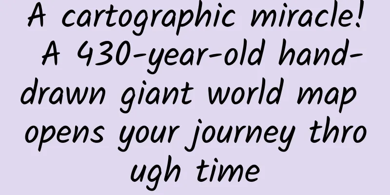
Leviathan's note: The world map by Urbano Monte in this article was drawn in 1587, which was the 15th year of the Wanli reign of the Ming Dynasty in China (those who have read Huang Renyu's "The 15th Year of the Wanli Reign" must have been deeply impressed). Did the Chinese at that time also draw a world map? The above picture is the "Great Ming Unified Map" drawn in the Ming Dynasty. Some people believe that it was drawn in 1389, because the map shows the administrative divisions in the 22nd year of Hongwu, the reign of Emperor Taizu Zhu Yuanzhang, but the exact date of drawing is still in doubt. It is one of the oldest East Asian world maps in the world. In this map, you can clearly see that it uses the Chinese way to depict the general form of the old continent - China is in the center, Mongolia in the north, Java Island in the south, Japan in the east, and Europe and Africa in the west. Compared with Urbano Monte's world map, the proportions are seriously out of balance. However, even the world map using the Mercator projection method in this article is certainly not as accurate as contemporary maps. After all, at that time, whether in Europe or China, people still imagined and misrepresented many places on this planet. Stanford University’s David Rumsey Map Collection has added a remarkable addition to its collection: a 60-page manuscript of a world map drawn by Urbano Monte (1544-1613) in 1587. At 9 feet square, the map/planetsphere is the largest known early world map. Monte hand-painted it in Milan, Italy, and only one manuscript copy exists. The map below is a digital scan of the 60 individual sheets, the first time in the 430 years since its creation that it has been assembled into a single, complete map as Monte had intended. The map projection is more than 9 feet in diameter and is made up of 60 smaller maps, with the North Pole at the center. Born in 1544 near Milan, Urbano Monte lived a life of luxury and comfort. This freedom meant that he could devote himself to his studies and amass a library that was renowned in his local area. In his early 40s, his interest turned to geography, and he spent 20 years compiling and amalgamating all the geographical knowledge known in the world at the time into a few volumes. Monte also wanted to create a world map on a flat sphere, writes map collector and scholar David Rumsey, who digitized these maps. Figure 23 Detail: Guyana, Venezuela, South America; a sea monster roams near the coast of Venezuela. Monte envisioned that all 60 pieces would be sewn together, so he left detailed instructions for assembling them into a single, massive world map, more than nine feet in diameter. In his dedication, he described in detail how to arrange the various parts of the planisphere, specifying that the map should be fixed to a 5.5 arm's length square board with a nail or pin driven through it at the North Pole, around which it could be rotated. This design was never realized, but it can now be done virtually. The following six pictures show how 60 triangular drawings and four square corner drawings are pieced together to form a complete 9-foot square plane sphere. First, the first ring is composed of 4 pictures (Figure 1-4), then the first ring is pieced together with the second ring composed of 8 pictures (Figure 1-12), then the first two rings are pieced together with the third ring composed of 12 pictures (Figure 1-24), then the first three rings are pieced together with the fourth ring composed of 18 pictures (Figure 1-42), and the first four rings are pieced together with the fifth ring composed of 18 pictures (Figure 1-60), and finally these five rings are pieced together with the four corners of the square, and the labels are added to complete the map. The effect of the first ring of the map being stitched together (Figure 1-4). The effect of combining the first and second rings of the map (Figure 1-12). The effect of combining the first three rings of the map (Figure 1-24). The stitching effect of the first four rings of the map (Figure 1-42). The effect of combining the first five rings of the map (Figure 1-60). The stitching effect of the first five rings and the four corners of the square on the map (Figure 1-12). Monte's map reminds us why maps were once so important historical sources: his planisphere map uses an Azimuthal projection, which contains scientific concepts that were very advanced at the time; the artistic techniques used in the map's creation and decoration reflect the highest level of design; and through the names of places, the shapes of space, and the comments interwoven into the map, the illustrator provides us with in-depth historical information on his vision of the world. Science, art, and history are reflected in the same document. Until now, Monte's map manuscript had been seen as 60 separate drawings. The only stitched version was a small, single-page summary in an atlas. Now that we have digitally assembled all 60 drawings (a task accomplished with great skill by Brandon Rumsey), we can appreciate Monte's remarkable achievement in a whole new light. The resulting map, just over nine feet in diameter, is one of the largest world maps of the 16th century. The detail and decoration of the map are breathtaking, and the work as a whole is undoubtedly unique in the history of cartography. Monte’s map was more than just a geographical tool. It showed the climate, customs, length of daylight, and distances between places within each region—in other words, he created a universal, scientific plane-sphere map. The atlas consisted of four volumes, which also included a detailed, multi-volume treatise on geography, the world, and cosmology. This chart shows the length of day and night for each month of the year (this chart is not included in the mosaic map). “Eclisse del sole”: illustration of a solar eclipse. Unlike most modern maps that use the Mercator projection, which also originated in the 16th century, Monte's map is set directly above the North Pole. Today, this projection is called the north polar azimuthal projection. If we georeference Monte's map and reproject it using the Mercator projection, we can immediately see why he used the north polar azimuthal projection instead of the Mercator: Monte wanted to represent the three-dimensional sphere of the Earth as completely as possible on a two-dimensional plane. His projection achieves this, albeit with some distortion around the South Pole. This distortion also exists in Mercator projections of the world, but Monte's map shows Antarctica much larger, allowing him to include the numerous geographical descriptions and speculations about Antarctica that appeared in the 16th century. Although the Mercator projection became the standard for cartographic mapping in later years because of its ability to accurately measure distances and directions, Monte's polar azimuthal projection provided a more intuitive representation of the relative relationships between the continents and oceans. In the 20th century, the era of aviation brought a renewed interest in representing the globe. Monte would be pleased to see that the official emblem of the United Nations uses a modern version of his map. Below is an image of Monte's map georeferenced and reprojected into the Plate Carrée/Geographic projection. This version of the map can be imported into Google Earth. Georeferenced and reprojected Monte's map using the Simple Cylindrical projection. The reprojected Monte Carlo map after importing it into Google Earth. When pieced together, the map reveals the cartographer’s highly personal and rich vision of the world, with an astonishing array of exotic animals, real and imaginary, reveling on land and sea. Ramsay scanned and pieced together this cartographic puzzle, and Monte’s work is now fully revealed for the first time: the largest world map of the 16th century, forgotten and neglected by most cartographers and scholars. Figure 1: Northern Europe. Monte did not acquire his geographical knowledge by travelling the world. In fact, much of the map is based on other maps common at the time, as well as lengthy texts describing the journeys of earlier travellers, and therefore reproduces various misconceptions of distant places from these sources, especially South America. Further research will hopefully reveal the exact texts to which he referred. His depiction of Japan, on the other hand, is the product of long-term independent research, as well as extensive reference to conversations with Japanese visitors to Italy in the 1580s. Although this section of the map is not identical to any modern map of Japan (and appears to be upside down), its level of detail is still impressive. Figure 9 Detail: Japan. Monte’s depiction of Japan was mostly based on information provided by the Japanese envoys to Milan and Italy in 1585, which was quite advanced at the time. Monte filled the map with exotic animals—crocodiles, camels, lions, and more. Near the coast of a land marked “unknown” (presumably in modern-day Alaska), a wolf with its cubs looks back warily. Elsewhere, more fantastical creatures exist only in fantasy, including griffins and a giant bird that appears to be clutching an elephant in its claws. There are mermen and well-armed fleets in the ocean. Political leaders such as King Philip II of Spain also appear on the map, and Monte also left several portraits of himself. Ramsay told CBC Radio that mapmakers didn’t like to leave blank spaces. “There were a lot of places they didn’t know the names of, so they filled in the blanks with trees and monsters,” he said. “They were using the map as a palette, and it was very artistic and interesting, and that’s why it’s so fascinating to us today.” Figure 24 Detail: Portrait of Philip II of Spain, coast of Brazil. Details of Figures 2, 7, and 8: Northern Siberia, Central Asia. Unicorns, dragons, and other creatures at play. In 1589, two years after the map was completed, and perhaps still revising it, Monte glued a new round portrait over his original portrait of himself at age 43, which now said he was 45. The new portrait was only partially glued on and could be lifted up, as shown in the picture: Fig. 42 Detail: Antarctica, Portrait of Urbano Monte, 1587 and 1589. Figure 25 Detail: Urbano Monte family coat of arms. Monte would probably be thrilled to know that his little-visited map is finally getting the attention it deserves. The public can view the original manuscript, which is still vivid in color, a full-scale scanned replica, and an interactive digital version at Stanford University. The map can also be explored online. Meanwhile, researchers are exploring this rare masterpiece and the valuable information it contains. They hope to better combine the text of the treatise included in the atlas with the text and geographical descriptions contained in the map itself. It would be of great significance to discover the sources cited in Monte's geographical works and to find out how he compiled this information to create his unique vision of the world in his extraordinary maps. All the pictures in this article are from David Rumsey's personal website: www.davidrumsey.com Text/Natasha Frost; David Rumsey Compiled by Kushan Proofreading/cutting light Original article/www.atlasobscura.com/articles/vast-map-planisphereurbano-monte-places-creatures-real-imagined; www.davidrumsey.com/blog/2017/11/26/largest-early-world-map-monte-s-10-ft-planisphere-of-1587 This article is based on the Creative Commons Agreement (BY-NC) and is published by Kushan on Leviathan |
>>: AI consciousness has "awakened", but humans are still kept in the dark?


Recommend
How to attract users with a budget of 0? Teach you 5 unique skills and talk about some traps!
Recently, some pure product personnel who work be...
It can grow up to 2 meters and live up to 100 years. It is not a python but a fish... Its bite is not very painful, but it is very scary.
Do you know what this fish called "river mon...
"Super Microscope" - China Spallation Neutron Source
Produced by: Science Popularization China Author:...
Drink this cup of coffee! What? How did you fall asleep after drinking it?
"I have to finish my manuscript tonight, let...
Breaking news: Mobile network is paralyzed and the entire electric vehicle ecosystem is facing "Black Friday"!
On the morning of October 16, some users reported...
Earning 6 figures a month by writing, my self-media entrepreneurship route!
If you only have one chance to turn things around...
Tesla says battery costs will drop by 35%, hinting at $125/kWh
According to foreign media reports, recent studie...
I am personally looking for a part-time job to promote Baidu SEM accounts. Can you please leave a message if you need any?
I do this too, have you verified it? Can I receiv...
Salute! These big names in the technology industry are all born in the Year of the Tiger
In the hearts of Chinese people Tiger represents ...
App Increment and Retargeting: User Segmentation
For a long time, or at least since advertising be...
Boss Dai from Fantong: "Yuanchuan Investment Academy"
Boss Dai from Fantong: "Yuanchuan Investment...
Resources|The most complete H5 sound effects library material website recommendation
When it comes to H5-related sound effects, many p...
Good news: mosquitoes are dying of heat in the south; bad news: they're heading north
August 20th is World Mosquito Day . This day is n...
Laughing, but not quite! How does your brain read emojis?
© Freepik Leviathan Press: The same sentence, for...